
Humberside Geologist No. 14
St Austin and the Fairy: a tale of two RIGS
Derek J. Gobbett
Prominent natural objects which do not conform to the general landscape are often imbued with magic or religious significance. This is the case with the hard, craggy rock masses, known as St. Austin’s Rock and the Fairy Stones, which contrast with the smooth rounded chalk topography of the Yorkshire Wolds. St Augustine is purported to have preached from St. Austin’s Rock and, according to legend, at midnight at the Fairy Stones one’s true love will appear in a vision (Cole 1883).
However, the purpose of this communication is more down to earth. Both exposures are currently Regionally Important Geological and Geomorphological Sites (RIGS) and have much in common geologically. Their location is shown on Figure 1. I will attempt to give a more detailed description of these rocks than has hitherto been published and to consider their origin.
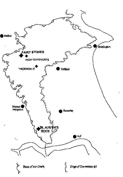
Fig.1. Sketch map of southeast Yorkshire to show the location of places mentioned in the text.
St Austin’s Rock
This rock lies at 130m above OD at the head of a typical dry valley, Austin’s Dale [SE 933 344] and pierces vertically the steep valley side. About 6m is exposed in vertical section and the rock covers about 300 m2 although it is currently considerably overgrown with brambles. Fallen blocks lie on the wooded slope below and pieces of the same rock type occur in the field above the exposure.
It is a breccia of angular flint and hard chalk cemented with calcite. The fragments vary in size from a few millimetres to about 20cm across; the larger fragments are of flint (Figs. 2-3). Bedding is obscure but some horizontal banding is evident (Figs.4-5). The cement consists of well-formed acicular crystals of sparry calcite up to 1 mm long which fringe the angular fragments, joining them together in places but not filling all the voids.
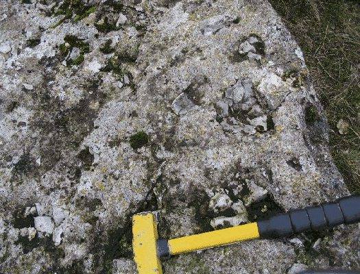
Fig. 2. Vertical surface of St. Austin’s Rock
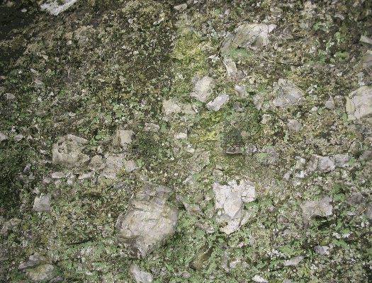
Fig. 3. Horizontal surface of St. Austin’s Rock
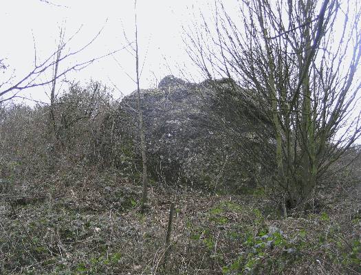
Fig. 4. St Austin’s Rock , view north
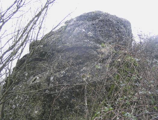
Fig 5. St Austin's Rock, view west.
Fairy Stones
These lie at 170 m above OD at SE 870633 high on the flank of Fairy Dale, close to the Burdale tunnel which formerly carried the railway line from Driffield to Malton.
They comprise two large stones separated by a widened joint, and two small stones slightly higher up the valley side: a fallen block lies near the base of the valley slope (Fig.6). The exposure extends vertically for about 10 m and covers an area of about 600 m2. The stones are formed of breccia almost identical with that of St Austin’s Rock in the nature and size of the fragments and the cement (Fig. 7). The bedded nature of the rock is however much clearer and shows a gently concave (catenary) form (Fig.8). The breccia also extends into the field above the exposure as a linear feature according to Mortimer (1885, p.38).
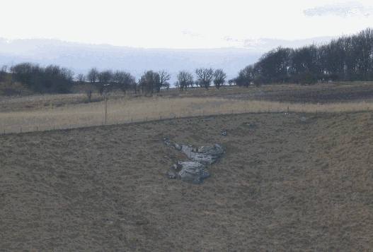
Fig. 6. Fairy Stones viewed west across Fairy Dale
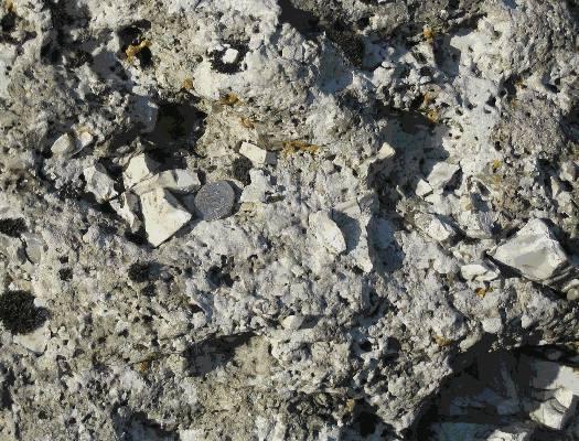
Fig. 7. Fairy Stones, weathered surface
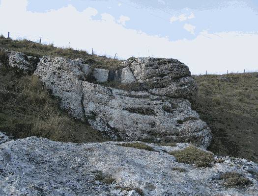
Fig. 8. Fairy Stones, view west
Other occurrences of similar breccia
Smaller masses of breccia which lithologically closely resemble that of St Austin’s Rock and the Fairy Stones have been recorded in other parts of the Wolds. Cole (1883, p83) mentions "a wall of flint breccia" with an average width of six yards exposed in a quarry at High Towthorpe. [The precise location of this quarry is mot known but it would probably have been in the kilometre square SE8863.] It could be traced in the quarry for 24 yds [22m] and further for some 220 yds on the surface of the adjacent field. He comments that similar masses are not uncommon in situ on other parts of the Wolds "and also occur as boulders, as at Fimber".
Mortimer (1885, fig.4) gives a drawing of what appears to be a smaller example in a chalk pit near High Towthorpe showing a body of "loose chalk gravel unwaterworn" within which is a vertical layer of "Chalk breccia very hard". This drawing is reproduced (re-drawn) by Dakyns and Fox-Strangways (1886). Mortimer (1886) shows other exposures of "Fairy Stone" near Towthorpe [SE 886645 and SE895634], the second of these being "17 yards [5m] long"; and also at Raisthorpe [SE 852624]. Blocks of cemented chalk and flint breccia are sometimes brought to the surface by ploughing. Good examples can be seen beside the Wetwang - Huggate road [SE 928 583] and beside the track in Thorndale [SE 938 582].
Origin of the breccias
The lithological nature and mode of occurrence of the breccias indicate fissure fillings which have not been transported any appreciable distance. Two main hypotheses have been advanced.
Mortimer (1885) considered them to be fault breccias. He was putting forward a theory of the formation of the dry valley pattern of the Wolds. He believed the dry valleys to have been initiated tectonically during the uplift of the chalk and he cited the ubiquitous presence of angular chalk and flint gravels in the valley floors as evidence of fault movement. Thus he interpreted his High Towthorpe section mentioned above as a fault breccia. De Boer et al. (1958) mapped a fault at Drewton Stray [SE 9233] based on a small vertical throw of the Cave Oolite. Although no displacement of the overlying Chalk could be ascertained they extrapolated the fault into the chalk, up St Austin’s Dale and concluded that St. Austin’s Stone was probably a fault breccia.
The other, perhaps more obvious explanation is that the breccias are sedimentary rocks filling solution fissures and /or pipes in the chalk. The extremely angular shape of the fragments and the general absence of any material other than chalk and flint might suggest that the breccia was formed by collapse of the overlying chalk into cave systems. However a collapse breccia might be expected to contain large blocks of the cave roof and there is no evidence of fragments larger than about 20 cm. Another possibility is that the breccia was swept rapidly into fissures during a period of flood. The fissures themselves could have been formed by solution of the chalk along major joint planes or may have been progressively opened mechanically by ice-wedging.
Most of the observed characters of these breccias do not support the fault breccia hypothesis. To make a mass of breccia as large as St Austin’s Rock or the Fairy Stones a fault would need to have had a considerable strike-slip movement under compressive stress, would be very obvious, and would almost certainly have been mapped. Also the rock shows no evidence of being ground to produce small particles to fill the spaces between the larger splinters. On the contrary there is typically a high percentage of voids suggesting no great degree of compaction before cementation. Quartzite pebbles occur scattered in some abundance on the higher parts of the Wolds according to Stather (1904) and Sheppard mentions that similar quartzite pebbles were obtained from both St Austin’s Rock and the Fairy Stones. This evidence and the presence of bedding clearly show the breccias to be sedimentary.
A large amount of angular debris suggests a cold climate in which weathering was dominated by freeze and thaw and there was a lack of continuous vegetation.. Rapid surface thaw could wash gravel into pipes and fissures at shallow depth. The fissures themselves are likely to be joint-controlled, whether they were karst features formed by chalk solution during some earlier epoch, or were due to contemporaneous ice- wedging under permafrost conditions. It seems likely that the gravels were formed during the Devensian and/or a pre-Devensian cold period. The nature of the calcite cement is characteristic of calcite precipitated near the surface by meteoric water draining down to the water table in the vadose zone (Tucker 1991). The cementation probably took place during a warmer interglacial climate.
References
Cole, E.M. 1883. Geological Rambles in Yorkshire. A Brown & Son, Hull, 112pp.
Dakyns, J.R. and Fox-Strangways, C. 1886. The geology of the country around Driffield. Memoirs of the Geological Survey England and Wales, Sheet 64, 24pp.
De Boer, G. Neale, J.W. and Penny, L.F. 1958. A guide to the geology of the area between Market Weighton and the Humber. Proceedings of the Yorkshire Geological Society, 31, 157-209
Mortimer, J R. 1885. On the origin of the chalk dales of Yorkshire. Proceedings of the Yorkshire Geological Society, 9, 29-42
Mortimer, R. 1886. The surface geology and modern enclosure of Fimber on the Yorkshire Wolds. Unpublished map, Hull and East Riding Museum, Hull.
Sheppard, T. 1904. Quartzite pebbles on the Yorkshire Wolds. Naturalist, pp.54-56
Stather, J.W. 1904. Quartzite pebbles on the Yorkshire Wolds. Naturalist, pp.9-11
Tucker, M.E. 1991 Sedimentary Petrology: an introduction to the origin of sedimentary rocks. Blackwell Science, 260pp.
(c) Hull Geological Society 1999 + 2007
copyright Hull Geological Society 2020