
Humberside Geologist no 8
published 1991
Commencing North of the Humber with the Yorkshire exposures on which Dr. Versey has given papers on their contours, and one of his latest included our particular area as well known by the Society's visits in past seasons.
South Cave with Red chalk resting on Kimmeridge Clay. There is also the A. plenus marls of the Hull & Barnsley Railway, of which the O.D. would be useful, as will appear later.
In the Society's Transactions Vol. VI part V a section at Hessle and South Cave was given by Mr. Stather, and one by Mr. Bisat Vol. VI part V on the section at North Ferriby.
Then Mr. Green, our Secretary, kindly informed me of the O.D. of the two bores at Springhead Waterworks of which the details were given in the Survey Memoir on the Water Supplies of the East Riding of Yorkshire here no A. plenus marl or Red Chalk were apparently noted.
Now by taking a traverse along the escarpment of the west of the Wolds, there is a published section of the beds observed at a specially low tide in the Society's Transactions Vol. VIII part III at which Red Chalk was noted and Kimmeridge Clay and as the belemnite fauna has shown in the opinion of Prof. Swinnerton to be low in that Series.
At S. Ferriby an excavation at the foot of the hill and turn to the Sluice Road showed a thin trace of greensands.
At the bye-road leading up the hill beyond the Church there was years ago a largish house of which the walls next [to] the road had settled and cracked so much that it was not habitable. This part had been built apparently at the juncture of Chalk and clay, as the next proof of Red Chalk occurred beyond the Plantation when excavation for the conveyor tower was made.
The Council Houses on the hill side were also on Clay and water had to be found upwards beyond the back fence.
Horkstow. A spring is mapped at [the] 100 ft. contour, and the Village pump was supplied by pipe from springs above the Village.
Saxby. Spring on Hill side. (The 2½" to a mile sheet has no contours, the contour edition is not yet published.)
Bonby. Spring at junction of beds above village near 200 ft. contour.
Worlaby. Base of Red Chalk exposed below Quarry by Almshouses on the road up to Middle Gate and Five Cross Roads.
There is a disused brickyard below this road.
Elsham. The greensands were seen on the hill out of the Village towards Barton and the Red Chalk and clay above the old sandpit and doggers on either side of the road up [the] hill towards Barnetby.
Melton Ross. At the Cross Roads above Barnetby Station, the Gallows Wood and Farm had below the plantation some traces of beds in the pipetrack excavations but on the hill top on the main road a field has boulders and liver-coloured quartzites and under this a trace of yellowish chalk resting on Kimmeridge Clay and at the North Easterly corner a Spring breaks out at the dip towards Elsham side.
Barnetby. At New Barnetby Cottages there are Springs and the main spring which is the source of the Skegger Beck break[s] out at the base of the Chalk which rests on Kimmeridge Clay.
A shallow well in drift and gravel resting on the clay on the Melton Ross side of Skegger Beck supplied the water to fields and paddocks.
Westoby put down a bore in one paddock "All in Kimmeridge Clay".
Now the Maltkiln on the opposite side of the road to Barnetby Station a drainage system was put with filter beds and Kimmeridge Clay some l0 feet under drift.
Barnetby Village had sundry wells in the gravel bank resting on Clay; the Vicarage being on Clay.
Barnetby Mill. A bore put down in the well by the cottages proved it had been sunk through the chalk.
Barnetby Old Church. A road side pump is fed by spring which seasonably overflows and is approximately the junction of the beds; a disused Chalk Pit is above. On the road to Bigby uphill is Chalk and one field westward has spring and hydraulic ram.
Searby Hill Top has a chalk quarry and yellowish chalk is cut into near the road side by it.
Grasby. This had a well by some houses, but record might be looked up, was proposed for water supply but no quantity. A house past the Inn on the left bored some 100 feet into clay.
Audleby. At the Top is chalk and on the road down to the Farm House and Buildings is exposed Red Chalk, and Carstone also at the back of the Farm House is sand apparently the Spilsby Sandstone, this bed being dug into across the "Park".
Two pipes were driven from the clay upwards at an angle to the Spilsby Sandstone base and clear water tapped, the older supply being meagre and blocked.
Caistor Town Well. Sunk in Chalk and deepened and later bored to Kimmeridge Clay.
Nettleton. Large chalk quarry on line above Caistor Church and the A. Plenus marl outcrops c.O.D. 415. On one of the Society's visits as far south as this a small fault and distortion was visible but now the plant has occupied this ground. Red Chalk outcrops at c.O.D. 300 with Carstone and old shallow pits and roadside embankment.
Claxby. The Airshaft to the old Claxby Mine a little way south of Acre Farm House (which is in the Normanby-le-Wold Parish).
[A] section [is] given in [the] Survey Memoir on Water Supply.
Normanby-le-Wold. Spring in Normanby Dale Wood, feeds ram and has been sealed and piped to take water during the latest War.
1/4 year to March 31. 1946 2,595,000 gallons.
1/2 year to March 31. 1945 2,237,000 gallons.
1/2 year to Sept. 30. 1945 4,595,000 gallons.
1/4 year to Dec. 31. 1945 3,023,000 gallons.
This would be the junction of Red Chalk & Carstone visible in excavations on the side of the Dale (but now replanted).
We again return to our South Ferriby records and restart another traverse following roughly the line on the dipslope to the South.
With South Ferriby as on Sheet 1. as a reference mark and some two fields away from Walker's ( now Eccles ) old Chalk pit, we have
Barton - Green Gate Farm. In Geological Survey Wartime Publication No. 12. East Yorkshire - North Lincolnshire the O.D. of this bore was given as c. 150 but on the 2½" to a mile Ordinance Survey map the 175 contour passes along the garden hedge and I have put it at c. 180 after inspection.
The Director of the O. Survey could not give any level of the Triangulation Station marked near the house, but gave me that on the latest Station monument which we passed the other year when returning from South Ferriby.
The Black Band was not noted (so its level at the Quarry will have to be taken)
Barton Cliff House. All Chalk
Barton Grange. Red Chalk. Greensand.
Chapel Farm. Well. A. plenus marl at pump stage level.
Kingsforth. Red Chalk. Greensand.
Deepdale. Not through.
Beaumont Coate. Through to clay.
Burnham Bore. (Earl of Y. Owner at that date). Chalk resting on Blue Clay. No Red Chalk or clays. Later you will see other sections of this area as to Clay levels.
Burnham Beeches. Well later after sale bored to Red Chalk and Greensand.
Burnham Manor. Through Chalk to much lower level ? tree dip here.
Wooton Dale Top. A. plenus marl zone noted and through
Worlab Top. Red Chalk and through to clay
" Freshneys ditto.
" ditto, but no greensand.
Burnham Lodge. Chalk only. Sufficient supply at that depth.
Wootton Grange. Said to be through chalk but only verbal.
Little Farm. Base of Chalk said to be yellowish but no sample visible. Rope bore.
Wootton. Dunkirk Farm. Red Chalk on clay and 20 feet into clay.
Mr. Bourne's Top. Well bored to clay. No remarks.
Mr. Riggall's Top. Bore replaced well which had been later bored and was fouled after with surface water. Greensand, 9'0" Red Chalk yellowish clay. l' 0" Greensand 17'0" Kimmeridge Clay.
Melton Ross. A bore by the Railway Bridge at the Chalk Hill Quarry by the Great Central Railway Co. gave A. plenus marl. Pink band and Red Chalk on clay.
Melton Ross to Stonecroft in the adjoining parish of Barnetby where l00 feet of chalk rested on Kimmeridge Clay c.f. Barnetby Mill later.
Kirmington Vale. Bore slight Greensand on clay.
Continuing on Dip Slope quite near the latter site.
Kirmington. Mr. Soweby's Top. A. plenus marl. - Red Chalk and then Greensauds.
Brocklesby with Little Limber.
Little Limber Grange. A bore below the 150 ft. well proved A. plenus marl, Red Chalk, trace of Greensand and clay.
Hendale Lodge A. plenus marl passed.
Limber Magna. Well and bore. Village water supply. Greenlands Farm. Rather east of our line but S.E. trend A. plenus marl. Red Chalk and Greensand.
Grasby Top. (nearer Escarpment than last) Well and bored to a certain level but not through. Property (a Trust) sold and a later bore put through, passing Red Chalk, slight Greensand to clay but the beds not detailed and previous bore not known to the new owner.
Audleby. A composite section on farm road for comparison.
Cabourne Mount. Well bottom in Red Chalk. Windlass and bucket muddied water at low level. Bored and then bored deeper in Greensands and clay.
Caistor. Town Well. for comparison as line diverts S. Eastward on Horncastle Road.
Cabourne. Mr. Hurdiss ( by Garage near Caistor Top.) Red Chalk and Greensands.
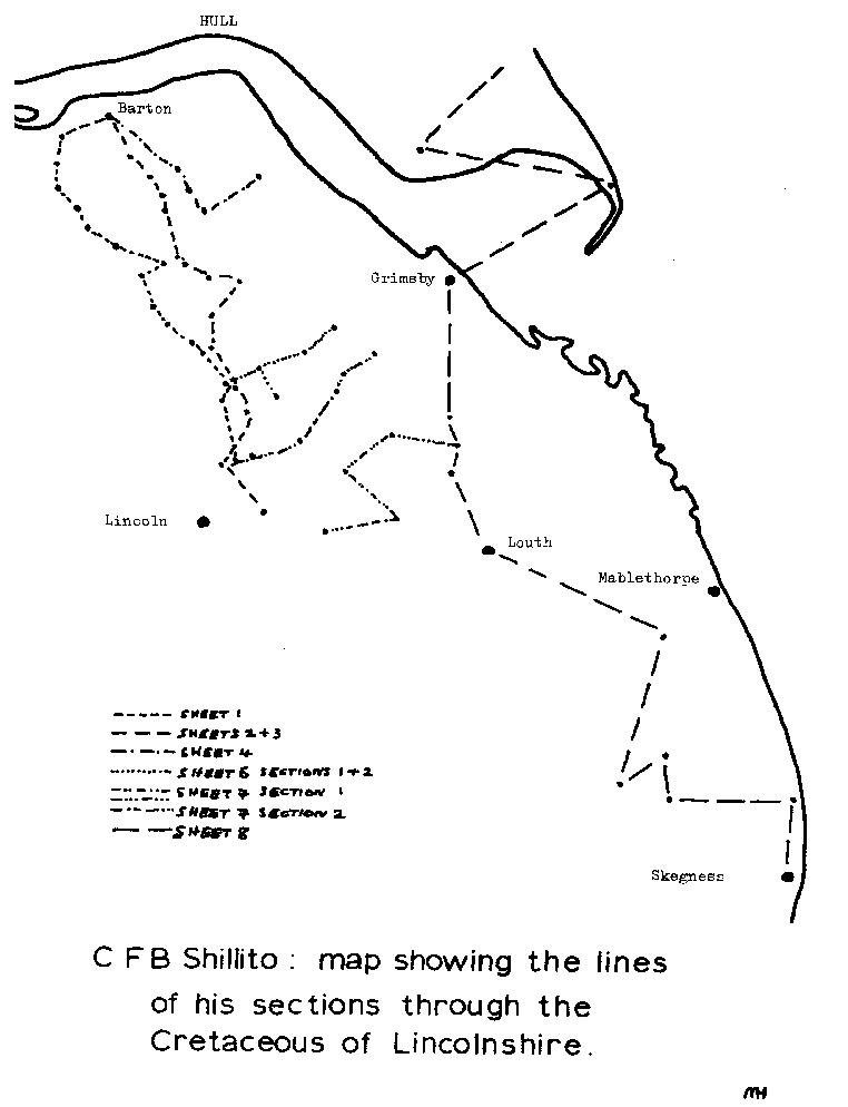
(Mr. Shillito goes on to describe other localities in note form, to make up a total of eight sheets of cross sections.)
copyright Hull Geological Society 2021