A guide to the Tills of Holderness
(a work in progress)
The cliffs of Holderness are eroding rapidly. The cliffs and the land behind them are composed of "drift" deposits that arrived in the area during the Ice Ages.
This unconsolidated sediment is called a diamict, till or boulder clay. It is composed of poorly sorted clay, silt, sand, pebbles, cobbles and boulders, transported mostly by glaciers. There are associated sand and gravel deposits in places indicating the melting of the glaciers. Also there are even some small silty lake and stream deposits from quieter times and the development of peat beds more recently. On the beaches of Holderness erratics can be found that have washed out of the cliffs.
It is important to remember a few facts about the boulder clays
Each glaciation will wipe away the stratigraphy of previous deposits
They are a heterogeneous sediment brought together by the glaciations from source areas, rocks flour from grinding the stones, rock exposures along the journey, previous tills, sea bed deposits and soils.
The erratics they contain will probably have been recycled during previous glaciations, i.e. the Shap Granite we find probably did not travel to East Yorkshire in one journey during the last glaciation.
It is likely that a large proportion of the "Yorkshire erratics" are derived from exposures on land that is now under the North Sea, i.e. not all the Speeton Clay fossils came from the present day exposure at Reighton.
The glaciers did not simple travel slowly to Holderness and slowly melt dumping their sediment content in their retreat phase. They were quite dynamic capable of loving up hill, pushing sediment in front of them, disturbing sediments beneath them and travelling quite fast, especially when they warmed up and started to melt.
Although the tills have been studied for over a century there is no simple scientific qualitative way to differentiate them apart from the colour of the matrix (they are all shades of brown really) and their erratic content.
Here is an attempt at a guide for fieldwork-
Hessle Till - forget about this; it does not exist!
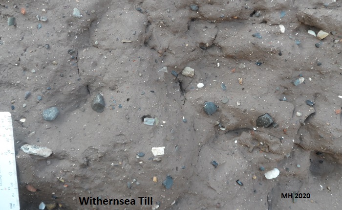
Withernsea Till - the type section is the cliffs at Withernsea. It is exposed on the Holderness Till, above the Skipsea Till, between Cowden and Easington. It used to be called the Purple Till. It is less sandy than the other tills. John Catt (2007*) lists these distinctive erratics in this till - Triassic limestones, shales and siltstones and Shap Granite. Catt (2007) describes the colour of the matrix as "dark brown" Munsell colour 7.5YR3/2 (hexadecimal colour code #59443A), weathering to "dark red brown" (Munsell colour 5YR3/4; hexadecimal #633E2A) or "reddish brown" (Munsell 5YR4/4; hexadecimal #825743).
The colour of the matrix is

and weathers to
 or
or


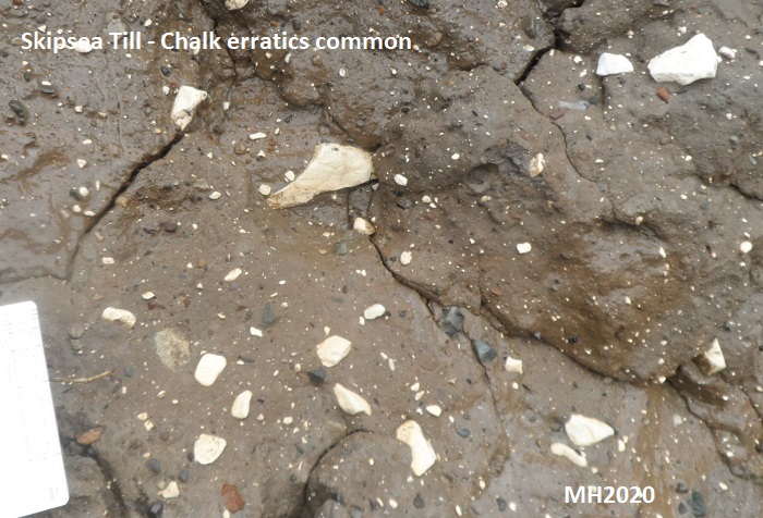
Skipsea Till - the type section is the Cliffs at Skipsea. It used to be called the Drab Till. It occurs along most of the coast. Catt (2007*) lists these distinctive erratics - Cheviot Porphyry, Greywacke and some Arctic shells. Catt (2007) describes the colour of the matrix as "dark greyish brown" Munsell colour 10YR3/2 (hexadecimal colour code #574539).
The colour of the matrix is


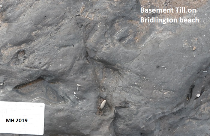
Basement Till - It is usually exposed on the beach at Dimlington and in the base of the cliff there. It contains fewer erratic pebbles and cobbles. The top is laminated, shelly and ruckled in places. Artic shells are common in this till - particularly Arctica islandica and Macoma baltica. Catt (2007) describes the colour of the matrix as "very dark grey" Munsell 5Y3/1 to 5Y4/2 (hexadecimal colour codes #49453B to #6C604D).
The colour of the matrix varied between
 and
and

This till is exposed on the beach at Bridlington very occasionally, and can be seen on the beach and in the base of the cliffs between Withernsea and Easington, though not continuously.

Older Drift - erratics on the higher parts of the Yorkshire Wolds provide evidence that earlier glaciations covered the Wolds but no tills remain.
Links -
* List of erratics by John Catt
List of Erratics found in the tills by Mike Horne
References -
Boston C M, Evans D J A & Cofaigh C O 2010. Styles of till deposition at the margin of the Last Glacial Maximum North Sea lobe of the British-Irish Ice Sheet: an assessment based on geochemical properties of glacigenic deposits in eastern England. Quaternary Science Reviews 29, 3148-3211
Catt, J A 2007. The Pleistocene Glaciations of Eastern Yorkshire: A Review. Proceedings of the Yorkshire Geological Society 56 (3): 177-207.
Perbang.dk website (accessed September 2020) - RBG chart and multitool (colour charts)
(c) Mike Horne & Hull Geological Society 2020