Open questions in East Yorkshire Geology
- answers from the amateurs.
By Mike Horne FGS.
[Read to the joint meeting of the Hull and Yorkshire Geological Societies on Saturday 8th October 2005]
Abstract
There is a long history of quality geological research in East Yorkshire by amateur geologists. G W Lamplugh carried out most of his research in the area as an amateur whilst living at Bridlington Quay, before taking a job with the Geological Survey in 1892. He worked on three main areas of interest - the Speeton Clay, the Chalk and the Quaternary deposits around Flamborough.
The Speeton Clay continues to attract many amateur collectors and some have published papers about its fossils including Danford, Ennis and Thompson. In the 1970's Lynden Emery studied the bivalves and gastropods for an unpublished thesis.
Lamplugh provided an early lithostratigraphy of the Chalk, which was followed by Rowe's biostratigraphy. A succession of Hull Geological Society members worked on the inland exposures; D W Toyne started a survey of the Chalk pits of the Wolds and when he died in a road accident the young Ted and Willy Wright continued the work until their research was interrupted by WW2. Felix Whitham and the Hull Geological Centenary Project produced a lithostratigraphy of the whole sequence in the 1980s and 90s.
The East Riding Boulder survey recorded the erratics of the region and W S Bisat's research included an accurate survey of the Tills in the Holderness Cliffs.
As well as continuing the research on the Chalk in recent years Hull G S members have informally revived the Boulder Committee and have been investigating the Quaternary deposits around Flamborough and the 'rafts' in the Holderness boulder clays. Members have also undertaken 'rescue geology' - recording and collecting from temporary or threatened exposures.
But is amateur research now under threat? Inland exposures are being filled (including fly-tipping in RIGS), university geology departments have been closed, there is a decline in the number of geology teachers in schools and the number of students studying geology 'A' level, libraries are replacing books and periodicals with computers and Hull Museums have just "deleted" the post of Keeper of Geology and will no longer be "pro-active" in the science. What can geological societies do to reverse these trends and encourage amateurs to carry out research? How can researchers continue to put their important specimens and data into the public domain?
Introduction
It was something that Pete Rawson said to me whilst we were planning this meeting that started to make me think about the contributions that amateurs have made to our understanding of East Yorkshire Geology.
The purpose of this paper is to review the contributions to our understanding of the Geology of East Yorkshire made by amateur geologists since the publication of G W Lamplugh's "Open Questions" paper, focus on some of the work by members of the Hull Geological Society in the last twenty five years and consider the future of amateur geology. It presents a personal view of these matters, just as Lamplugh did in 1898. And for convenience it will deal with the geology in the same sequence.
There has been a long tradition of amateur geologists carrying out research in our region going back to before the foundation of the Hull Geological Society in 1888 (Horne 1989). Perhaps half of the research in the region since the Society was founded was carried out by amateurs, or amateurs who later became professionals, like Lamplugh.
G W Lamplugh was born in Driffield in 1859 (anon. 1927). He lived at Bridlington Quay and his work as an amateur geologist was centred around Flamborough. It included the lithostratigraphy and biostratigraphy of the Speeton Clay, a lithostratigraphy of the Chalk of Flamborough, an excavation of the Sewerby buried cliff and other studies of the Quaternary deposits of the area. He joined the Yorkshire Geological Society in 1878 and published eight papers on the Quaternary of the area in the following eight years, including a paper on exposures of the Bridlington Crag and a report of an excavation of the Sewerby Buried Cliff funded by the Society (Davis 1889). He was an amateur geologist until the age of 33, when he took a job at the Geological Survey in 1892 (ibid.).
As a professional he encouraged amateurs to carry out research
(1898, 1906 & 1910) and stressed the importance of the amateur
approach - having an open mind and holistic view.
In his 1898 'Open Questions' talk Lamplugh not only demonstrates
the breadth and depth of his own knowledge of local geology in an open-minded
way, but he gives us a 'snapshot' of the geological progress of the time
in general. I find it fascinating that Lamplugh was speculating about
such "modern" concepts as eustatic tilting of Britain after the Ice Age,
the affects of the precession of the equinoxes and other 'cosmic processes'
causing global cooling, and the use of geophysics to investigate the cause
of the 'Pre-Cretaceous anticline in the neighbourhood of Market Weighton'.
To me this points out that either we have achieved so little in 100 years
or that Lamplugh was indeed ahead of his time!
[Note:- in the following text the 'Society' refers to the Hull Geological Society and 'Transactions' to the 'Transactions of the Hull Geological Society'.]
This paper focuses on the work of amateur members of the Hull Geological Society in the Flamborough region, or those who later went on to become professionals. It therefore ignores the excellent research carried out by professional geologists who are/were members of the Society, such as Lewis Penny and John Neale, and their research students and associates.
Speeton Clay
The Speeton Clay is ever popular with fossil collectors. It contains some unusual fossils - delicate "shrimps" and uncoiled ammonites, along with numerous belemnites. There are also rarities: squat lobsters, other crustaceans and the only dinosaur yet to be found in East Yorkshire.
But it does take an effort to understand the stratigraphy of the Speeton Clay, but once you get to know your way around these slumping grey clays they are very rewarding and the fascination will keep drawing you back. The landslips, shifting beach levels and ephemeral beach exposures mean that you can never be sure what you will find. Though things remained fairly stable in the 1980s and 1990s, there have been some dramatic changes in the last few years and some of the distinctive features have been washed away. I am not sure that we have really got to grips with the Upper B beds and the A beds always seem to be affected by thrusting.
There has been some important work done by amateur members of the Society, but there was also a dynasty of academic geologists starting from the work of John Neale at Hull University in the 1960s.
C G Danford lived at Reighton Hall and published papers on the Speeton Clay fossils and Shell Bed in 1906-7.
W C Ennis published papers on the upper beds of the Speeton Clay in 1932 and 1937.
Jack Doyle, a Hull graduate, teaching in Hertfordshire, is often to be
seen on the cliffs at Speeton collecting ammonites. His collection is
now mostly in the Yorkshire Museum.
Lynden Emery studied the stratigraphy and the molluscan fauna of the clays (1974, 1978). His M. Sc. thesis names new species of gastropods and includes several palaeoecological reconstructions. His carefully curated collection is now in Hull Museum.
Chalk.
To be honest the Chalk is not the most "sexy" of rocks: at best it bores most geologists and is frequently insulted. It is white and there is a lot of it. The fossils are white and if you try to collect them they usually break. To break the monotony it contains flints and marl bands, but we don't know exactly why! If the Speeton Clay requires dedication to understand, the stratigraphy the Chalk requires the patience of a saint!
Lamplugh published a detailed lithostratigraphy of the Chalk around Flamborough in 1895. Subsequently Rowe published a series of papers about the Chalk around the English coast. The Yorkshire part was published in 1904. Rowe contended that the biostratigraphy was the key to understanding the Chalk, and this led to a long period of time when geologists did not bother measuring sections (Gale & Cleevley 1989).
The coastal sections having been sorted out, local amateur geologists concentrated their studies on the inland exposures. The Mortimer brothers had for a long time collected fossils from Chalk pits for their museum in Driffield. This collection was later transferred to Hull and then 'lost' when the Museum in Albion Street was bombed in 1944. Many specimens have since been found in the Phoenix excavation of 1989 and are now again in storage in High Street awaiting re-curation.
W C Ennis published papers about the Chalk fossils and bio-zones in the late 1920s and early 1930s.
Ted and Willy Wright joined the Society in 1930. As teenagers their mother took them and their friend Robert Stainforth out for car rides to the coast. In 1932 a paper was published by W K Spencer of the Natural History Museum about a starfish they had found on the beach at Flamborough; though Robert Stainforth told me that their mother had found it when they were having a picnic, saying "that looks just like a set of false teeth!" They were soon exhibiting specimens and speaking at Society meetings and publishing lists of chalk fossils, with the encouragement of Thomas Sheppard.
D W Toyne (about whom I know very little) had started
to record the geology of the Chalk pits inland. When he was killed in
a traffic accident the Wright brothers inherited his notebook and then continued
the work (in what looks to have been originally their Latin grammar notebook!).
Unable to continue this research during WWII they published their results
in 1942. Willy went on to become an expert on Chalk ammonites and echinoids,
publishing monographs. Ted became a respected amateur maritime archaeologist
following their discovery of the Ferriby boats.
Felix Whitham has several research interests - his collection includes
splendid fossils from the Cave Oolite, Kellaways Rock and Chalk. An early
research project involved raking the top of the Carstone exposure at
Melton Bottoms with a home-made rake to collect rare brachiopods.
In 1984 the Society started the Centenary Chalk Project (Horne 1988) to collect Chalk specimens and create a lithostratigraphy for display at the Centenary celebrations on June 2nd 1988. Felix Whitham passed on his experience of research into the chalk and led several of the early field meetings. Quality Chalk fossils were collected from known horizons and it was hoped that eventually these would be donated to Hull Museum. Exposures at inland quarries were measured and these were pieced together to create a composite section through the lower 180 metres of the sequence. The coastal Chalk around Flamborough was also measured and this compares very well with Lamplugh's 1895 publication. The only major problem we had there was solved by Donald Beveridge who pointed out that a section of the cliff near South Landing had slipped as a block, but this was only obvious from the low tide line - meaning that we had a duplication of about 12 metres of the sequence in our original 1986 log.
Following a suggestion from Malcolm Hart at Plymouth in reply to a request in
the Geologists' Association Circular I started collecting marl samples
for the study of the foraminifera. The opportunity later arose to do some geochemistry
on some of the samples, with the help of Richard Middleton, and this led to
the discovery that some of the marl bands were originally volcanic ash falls
(Horne 1996). Sadly there has not been the opportunity to continue this work
and produce a complete chemo-stratigraphy of the Yorkshire Chalk.
The Black Band Member has always generated a special interest for local geologists, and there are scattered records of exposures in the Society archives, Transactions and Humberside Geologist from the amateurs in the Society (e.g. Walton 1888, Horne 1995, Hildreth 1999).
By coincidence we are now in the position to answer some of Lamplugh's "open questions" about the Chalk and ask a few more:-
Total thickness of the Yorkshire Chalk -
Lamplugh wrote suggested that "its thickness could not be less than 1270 feet, and might be considerably more."
To some extent the answer to the question "how thick is the Chalk?" is "it depends where you measure it!"
The measurements made by the Society's Centenary Project show that there are 179.5m exposed in the inland sections, 181 m on the Flamborough section and 26 m at Nafferton. This gives a composite minimum total of approximately 386.5m or approximately 1268 feet, ignoring the gaps in the sequence, or the variation in thickness across the region.
| Author | thickness in feet | thickness in metres |
| Barrois 1876 |
637
|
194.2
|
| Blake 1878 |
790
|
240.8
|
| Lamplugh 1898 |
>1270
|
>387
|
| Jukes-Brown 1903-4 |
1270
|
387
|
| Rowe 1904 (white chalk only) |
1013
|
308.8
|
| Ennis 1929 |
1416
|
431.6
|
| Wilson 1948 |
1432
|
436.5
|
| Neale 1974 |
1400
|
426.78
|
| Wood 1980 |
1735
|
529
|
| HGS 1988 |
>1268
|
>386.5
|
There are still gaps in our knowledge though. We need more exposures to sort out the sequence at the
top of the Burnham and the bottom of the Flamborough Formations. We only
have a few exposures in the binodosus zone: the correlation between Nafferton
and Bessingby is not certain, higher exposures in the sequence (such as
White Hill) are no longer available and we have no idea what happens between
the top of Sewerby Cliff and the inland exposures higher in the sequence.
If we were to add in a estimate for the non-exposed Chalk we would probably
get a total of about 430m (approximately 1430ft).
The flinty-flintless boundary -
"But it remains yet an open question whether the upper limit of the occurrence of the flint-nodules holds constant in the interior, or whether, as I believe MR. MORTIMER still thinks, the flints may in certain localities invade both higher and lower zones." We are not really in a position to answer this as we do not have the necessary exposures. But for two reasons my gut-feeling is to agree with Mortimer. The exposures at Selwicks Bay, Stottle Hole and Langtoft do not match very well. Also we still don't know how and why flints form. If flint formation depends on water depth and rates of sedimentation then they may be diachronous.
The flinty-flintless boundary has been taken as a stage marker between the Coniacian and Santonian by many workers, but there is no real bio-event evidence to support this at present.
Biozones -
In his paper Lamplugh seems to be urging us to collect specimens stratigraphically so that we can create our own biozones for the Yorkshire Chalk. He suspected that Barrois's biozones may not be totally applicable. We have come some way since then, with the use of 13 biozones for the sequence, but some of them, particularly the "rostrata" zones, are unsatisfactory. The zone we use have not been properly defined using bio-events at their base - which also leads to confusion. Some of the zonal fossils we use overlap stratigraphically, but as there is no standard definition of the zone we cannot be sure what authors mean when they use them!
It is a pity that our Centenary Project did not go a little further and create new zones starting with a clean sheet rather than perpetuating the need to us southern Chalk zones. This might have been done with the use of species of Inoceramid bivalves and belemnites, as used in Germany. Neither did we take the opportunity to clearly define the zones that are in use with biological events rather than lithostartigraphic horizons.
Thinning of the Chalk -
Lamplugh notes the thinning of the Red Chalk and Lower Chalk Formations in parts of the region. We now know that the Red Chalk Formation varies considerably across the region due to the Market Weighton Structure, being over 2m thick at South Ferriby, 1m thick at Rifle Butts SSSI and about 10 m thick at Buckton. The Ferriby Formation (or Lower Chalk) is also affected being about 24m thick at South Ferriby, 22m at Melton, 12m at Drewton (Hull G S archives) and 44m thick at Buckton (Simon Mitchell, pers. comm. 1997). The Turonian Chalk seems to have a pretty consistent thickness across Lincolnshire and Yorkshire. But there are indications that other parts of the sequence vary in thickness, but lack of exposures means that we cannot be sure. For the best example we have - it is not easy to correlate Queensgate Pit with the coastal section as the lithostratigraphy does not match very well and the biostratigraphy is hampered by poorly defined biozones - but it would seem that zone is slightly thinner inland.
Rate of accumulation -
|
|
thickness |
Ma |
rate |
Ma |
rate |
Ma |
rate |
Ma |
rate |
|
L CAM |
92+m |
2.5 |
37+ |
2.63 |
35+ |
3 |
31+ |
3.23 |
28+ |
|
SAN |
113m |
4 |
28.5 |
3.5 |
32.3 |
2.5 |
45.2 |
2.3 |
49.1 |
|
CON |
70+m |
3 |
23+ |
1 |
70+ |
3 |
23+ |
3.5 |
20+ |
|
TUR |
86m |
1 |
86 |
2.5 |
34.4 |
4.5 |
19.1 |
4.2 |
20.5 |
|
CEN |
23m |
5 |
4.6 |
6.5 |
3.5 |
5.9 |
3.9 |
6.1 |
3.8 |
It does depend on which published time-scale we take as our standard, but the sedimentation rate (shown here as metres per million years) does seem to increase through the sequence.
|
Notes - We only have Lower Campanian in situ in East Yorkshire There seems to be agreement that the L CAM takes up a third to a quarter of the stage - so I have used a figure of one quarter the total age of the stage for the L CAM. The time-scale sources are (from left to right) :- Anderton et al 1979, Palmer 1983, BGS 2000 and ICS 2005. |
Depth of water -
We have very little evidence on which to base an answer. All I can say is that there are very few hard-grounds (most of those are in the Cenomanian Chalk) yet there seem to be fewer keeled planktonic foraminifera in samples when compared to samples from southern England (though by necessity I have had to work with marl band samples because the Yorkshire Chalk is so hard!). I have a feeling that the water depth and slope of the seabed may have been greater in the Flamborough area - based on the thickness of the chalk sequence and indications of sediment slide structures.
Beyond Lamplugh -
The amateur geologists have also managed to take studies with Chalk stratigraphy further than Lamplugh suggested - through the use of microfossils and geochemistry (1996).
|
The members of the Hull G S Centenary Chalk Project were:- Donald Beveridge Eric Chicken Lynden Emery Kenneth Fenton Dave Finer Tony Gear Ron Harrison Mike Horne Mavis May Richard Myerscough Stephen Potts Tom Scott Roy Thackery Felix Whitham |
When Felix Whitham read his Chalk stratigraphy paper to the Yorkshire Geological Society meeting at the British Geological Society in Keyworth, the President remarked that this was the sort of work that professional geologists no longer carry out because they don't have the time to do long term dedicated studies!
Quaternary
The Quaternary is our most recent geology and there is a lot of it in Holderness. In fact without it there would be no Holderness! But our understanding is patchy, mainly because the exposures that show the relationships between the various deposits are patchy! Just as early geologists struggled to reconcile a long geological history with the Biblical creation mythology and the Flood, we have over the years struggled to fit the Holderness Tills into changing Quaternary chronologies. Though many geologists dismiss it as "gardening", it is probably the most challenging of our local geology, because so many pieces of the jigsaw are missing. It is also a blessing because of the rich variety of erratic fossils and rocks - when beginners ask me whether Speeton, Whitby or Robin Hood's Bay are the best place to start collecting, I reply "go to Hornsea, Withernsea or Spurn!!"
W S Bisat FRS - joined the Hull Geological Society in 1920, when he moved to North Ferriby (Boylan 2003). He published 26 papers about local geology between 1921 and 1962, especially about the North Ferriby area and produced early records of the Dimlington Moss Bed. Catt and Madgett (1981) published the superb sections of the Holderness coast compiled by Bisat at a scale of 6 inches to the mile, a task he started in 1931 (Boylan 2003), showing the numerous layers in the tills.
Hull Geological Society Boulder Committee was started in 1892 and rapidly started to publish records of erratic boulders. This continued until WWI and the committee was finally disbanded in 1935. It was revived in 1987 mainly celebrate the Society's centenary and as a means of involving members in an informal group research project. The results have been published in our journal (Harrison & Horne 1992, Horne 2000 & 2001). Collating the data has shown some interesting distribution patterns of erratics (not all strictly boulders in size) on the Holderness coast (Horne 2004).
Members of the Society are also at present involved in research suggested by Ian Heppenstall in the Flamborough area, comparing the stratigraphy and sedimentology of the deposits at Speeton, Sewerby, Danes Dyke and South Landing. This has also necessitated collecting samples from the Tills of Holderness to act as standards.
The "rafts" within the Tills have also held a long fascination for amateur geologists. Lamplugh discusses the Selwicks Bay raft in his publications. Bisat shows some in his sections of the coast. The Chalk rafts seem to contain black flints, Belemnitella mucronata and Upper Campanian microfossils (Horne unpublished research). But what are the other rafts? Are some Tertiary in age (one I have sampled seems to be) and are others recycled earlier Quaternary Tills?
This recent research is still ongoing and as yet unpublished, so it would not be right for me to go into details here or propose models to explain the geology of the area - but we will have a look at some of the sites and discuss the possibilities during the field meeting that accompanies this talk.
The erratics on the Wolds are also still worthy of investigation - some have suggested that they are evidence of the erosion of Tertiary rocks or are the remnants of earlier glaciations? In the past Mortimer and then J W Stather looked at them, and now the Society is showing an interest again.
But all of these projects are being done on a long-term basis, gathering data when the opportunities arise and eventually a picture may emerge when they are put together.
Others.
I have not mentioned some other important amateurs who have influenced our understanding of local geology, mainly because they did not concentrate on the Flamborough area.
John Walker Stather (1857-1938) was the Secretary of our Society for all of its first 49 years and published nearly 100 papers about local geology. His main interests were with the glacial and coastal erosion committees of the YNU, and investigations into the fossiliferous deposits at Kirmington and Bielsbeck.
Thomas Sheppard (1876-1945) was famous for being the energetic Curator of Hull Museums. But he published his first geological paper in 1895 and carried out much research and publishing nearly 40 papers whilst employed as a clerk for the North Eastern Railway until 1901. As a professional he went on to encourage young amateurs to carry out research and publish.
And Lamplugh did not mention in his lecture the Jurassic rocks to the west of the Wolds. Nor the search for the Tertiary - the truth is out there!
The future of amateur geology.
In the last 20 years there has been a trend towards group or collaborative research within the Hull Geological Society - Centenary Project, Boulder Committee and Flamborough Quaternary Research Project. As well as these longer projects there have been some instances of "rescue" geology (to pinch a term from our archaeological colleagues). These are smaller projects with a shorter time-scale dictated by the temporary nature of the exposure or a threat to the site. Examples are the Market Weighton By-pass (Horne et al. 1995), North Cave Wetlands and Jurassic Karst Features at Newbald Quarry (Horne 2003).
The increase in popularity in geology from the 1960s led to serious consideration of the need for conservation and ethics. The Geologists' Association Geological Fieldwork Code says that we should "avoid removing in situ fossils, rocks or minerals unless they are genuinely needed for serious study" and " ensure that ... research material and notebooks eventually be made available to others by depositing them with an appropriate institution".
But is amateur geology and research on the decline or under threat?
Let us first consider the needs of an amateur geologist:
There are some dark clouds on the horizon:-
Education
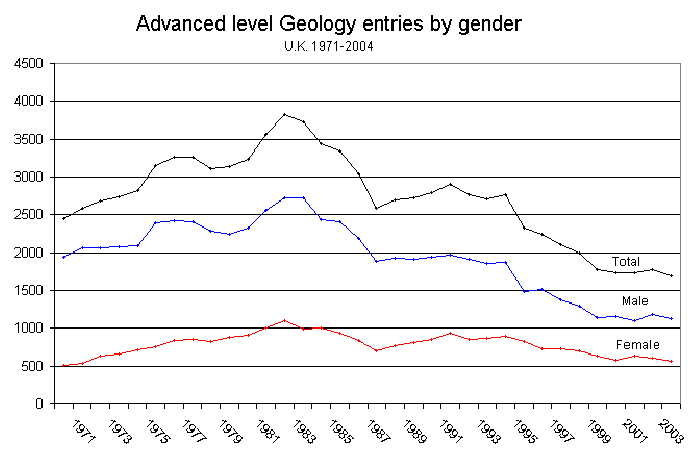
There has been a decline of the teaching of 'A' level geology in our region. Nationally the number of students entered for 'A' level geology has more than halved in the last twenty years; from a maximum of about 3 700 in 1983 to about 1 700 in 2004 (C King pers. com. 2005)
There has been a reduction in the number of schools teaching 'A' level geology in the region - six out of seven schools and colleges (that I know of) no longer teach the subject. The remaining one dropped it for a couple of years recently but has restarted with two part-time staff. A pair of schools started to offer the subject in a joint class. Peter Kennett tells me that there is a similar trend in South Yorkshire, with only four centres now offering the subject.
The National Curriculum was introduced into schools in 1988. The geology in the Curriculum has mostly been taught by non-geologists. (Kennett pers. com. 2005 see Appendix 2). Concern over the decline in the standard of the teaching has led to the founding of the Earth Science Education Unit (ESEU) at Keele University in 2004 to provide In-Service Training to teachers of secondary science by experienced geologists.
The closure of University Geology Departments (e.g. Hull, Sheffield and Oxford Brookes) not only affects the education of geologists. It has led to the dispersal of collections, the reduction in the number of "appropriate institutions" for the donation specimens and a reduction in the advice and research facilities that are available to help amateurs.
[ Though I must, at this stage, point out that the Geography Department at Hull University has continued to support the Society since the closure of the Geology Department and allowed us to use their laboratory facilities. Without this help some of the research the Society is doing would not be possible. We are extremely grateful for this help. ]
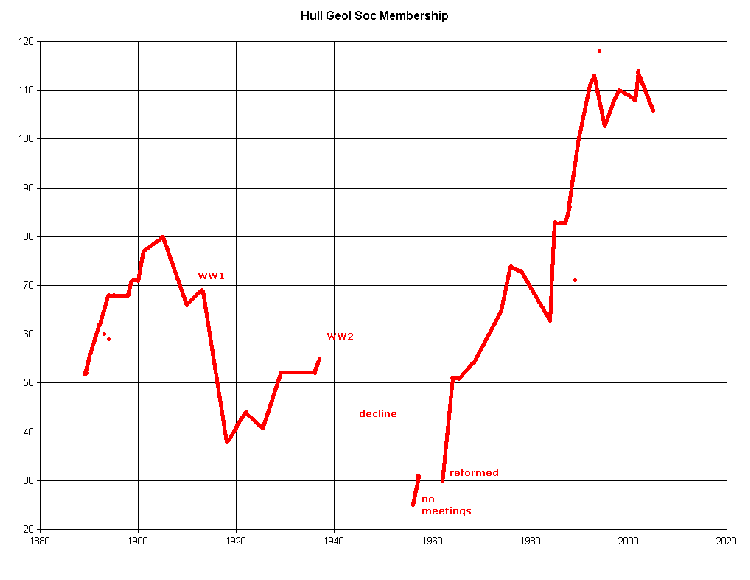
Geological societies have played a huge role in encouraging beginners and research, through their lectures, field trips and publishing. But societies are dynamic - made up of the sum input of their ever-changing membership. Looking through the history and membership records of the Hull Geological Society we have seen quite large fluctuations in membership, partly brought about by external conditions - war economies, the petrol crisis, &c. There are now more graduates in the Society, but fewer FGSs and no FRSs any more (there have been five in the past).
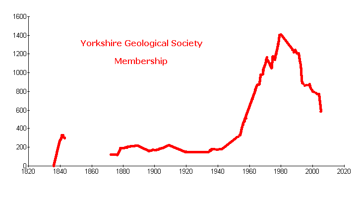
Young people are not joining Societies, clubs and professional bodies. The increase in the number of specialist groups and journals might explain why young professionals no longer join their accepted professional body or regional societies. The membership of the Yorkshire Geological Society has almost halved in the last 25 years, declining from its peak of 1409 in 1980 to 774 in 2004.
Why aren't there young amateurs like Lamplugh, Ted and Willy Wright, Tom Sheppard publishing articles in our journals today? Are they daunted by the "academic" dominance of our science or are they just not there anymore?
Conservation
There is a decline in the number of inland exposures. Small quarries are filled in and new quarries can only open if there are plans to re-instate the land afterwards.
Taking the Chalk as an example - in Mortimer's time "there was a pit in work every mile or so along the roads of the Wolds" (Wright & Wright 1942) and he was able to collect a huge number of fossils that are now in Hull Museum along with his field maps. In 1942 Wright and Wright listed 125 Chalk exposures in the Yorkshire Wolds; the HGS Centenary Project recorded about 36 Chalk quarries and some temporary exposures. Of these four of the larger quarries are landfill sites and some of the smaller ones are badly overgrown. The East Yorkshire RIGS Group was founded in 1992 and has listed 23 Chalk exposures as Regionally Important Geological and Geomorphological Sites and there are also three Chalk SSSIs in East Yorkshire. Two Chalk RIGS have been lost to fly-tipping and the local authority does not have the power to get the waste removed. Access for geologists to one important site has been refused by the operator, at others permission to visit can sometimes be difficult to obtain or there may be restrictions placed on the visits.
Many societies, RIGS groups and conservation projects have chosen to actively promote geology with the public. The Dinosaur Coast Project leads public walks, RIGS groups have published leaflets about local sites and I have had 300 people attend a walk I led for Science Week. We are taking a gamble - opening the door to our science in the belief that people will enjoy the glimpse and understand why we think it is important, hoping that one or two will become responsible geologists in the future and praying that they don't take a sledgehammer to our favourite exposures.
There has been an increase in the sales of geological specimens in shops, at car boot sales and on e-bay. For an example text from the Society's journal was recently plagiarised in an advert for a dinosaur footprint that was collected from a sensitive site for sale on the internet (Horne 2005). The important footprint sites on the north Yorkshire coast have no conservation status and there is nothing to stop people collecting these important trace fossils for commercial gain.
There is a need for some co-ordination between the
RIGS Groups in Yorkshire and surrounding areas. There are problems of some
areas having no geoconservation cover and some which are covered by two
Groups, leading to duplication of effort and resulting potential lack of
credibility with planning authorities and land owners. There are differences
in approach from the Groups, some wanting site designation merely to protect
sites from abuse and others wanting to actively promote the use of sites
by the public. Unfortunately the Yorkshire Geological Society disbanded
its Conservation Committee in 2003.
Public domain.
Palaeontologists and stratigraphers need access to old publications. The identification of species in the natural sciences, including palaeontology, is based on the description of type specimens; we need to be able to go back to those original descriptions.
All scientists, including geologists, need access to current publications to keep up to date with new ideas nationally and internationally. It takes several years (or even a couple of decades) for new theories to make their way into popular textbooks. This access is probably more critical for amateurs who mostly operate on the edges of academia, or even without any contact with the professionals.
The coming of the world wide web has provided the means for easy access and rapid publication. But we have not yet taken advantage, most UK Universities hide their teaching behind passwords and few journals are published free on-line.
Books and periodicals are being thrown out of libraries (for example at Hull, Lincoln and Leicester Universities) due to lack of space and changing priorities. A University Library "is not a historic repository, nor can it retain everything that might by chance become a future subject of interest." (R Heseltine, Hull University Librarian, memo 1st February 2002). Periodicals are considered to be out of date if they are more than 35 years old and books that are not borrowed regularly are no longer needed! (appendix 4) Yet our science, particularly in the field of palaeontology, requires access to the first published record of type specimens or exposures!
There is a similar trend in civic public libraries, with a reduction in the number of books in the Hull Central lending and reference libraries. But libraries do seem to be replacing the books with computers, unfortunately most geological journals are not freely available on the internet!
There is also a decline in museums - both in the quality of display information and geological curatorial staff numbers.
One easy way to get an introduction to the local geology is to visit the display at our local museum. We should also be able to compare the specimens on display to help us identify material in own collections (that's how I learnt a lot of my geology in my early teens). But the quality of the information accompanying displays seems to becoming 'dumbed down'. For example in Hull Museum the 33 bivalves and 21 brachiopods on display are all identified as "shellfish" and we are informed that "Fast moving lobsters chased belemnites for their lunch". (Horne 2002)
Hull Museum, after over 100 years of support for geological research in the East Riding, has just "deleted" the post of Keeper of Natural History and Geology and will no longer be "pro-active" in those fields ( J Taylor, pers.com. appendix 3). Where in the future will researchers deposit specimens and data to back up their publications and act as a resource for future generations?
The future?
Whilst we do seem to be generating more interest in the earth sciences amongst the public - our ability to offer support seems to be declining. If we only offer an introduction suitable for Key Stage 2 or 3, how can we expect collectors to progress to do research in an ethical way? If we cannot protect sites why shouldn't people collect from them? If collectors cannot donate their specimens to the local museum their only option is to sell them or see them thrown into a landfill tip that used to be a RIGS!
Are we witnessing an end to altruism? Do we care?
Conclusion. ( added after the meeting )
In the introduction to the History of the Hull Geological Society (1989) I remarked that when the Society was founded there seemed to be a holistic approach to the "natural sciences" - the natural sciences were not subdivided into specialities and there no real separation between the amateurs and professionals.
In the meeting I was fascinated to hear Rory Mortimore's lecture about the Yorkshire Chalk. It would seem as if we have been studying the same topic quite independently and it was gratifying that we often got the same results! But there were some things there from recent publications I had not come across before and I had some answers to some of his questions. It was also reassuring that some of the questions that John Catt posed are areas that the Hull Geological Society are also wishing to solve.
I have found from experience that the more research I do the more questions I find! But one of the advantages of amateur research is the freedom - there is no one to tell you what you should or shouldn't do and you can take as long as you like to do it. This means that the amateur can take decades gathering data and specimens, taking advantage of temporary exposures, and with the patience to wait for them to reappear. We can do our research without pre-conceptions and ask naive questions; is this what Lamplugh meant by the "amateur spirit"? The disadvantage, of course, is that there is no pressure to reach a conclusion and publish!
Is the gap between the amateur and professional still growing? It will be affected by some of the problems I highlighted in the second part of the talk.
The larger geological societies, like the Yorkshire Geological Society and the Geologists Association, are probably the interface between the professional and the amateur. They may also have to fill some of the void left by the dwindling of the teaching of 'A' level geology, closure of University departments and the cutbacks in museums and libraries.
Acknowledgements -
I wish to thank Chris King of Keele University, Jack Doyle (Hertfordshire), Lynden Emery (Castle Cary), Peter Kennett (Sheffield) and Will Watts (Scarborough Council) for providing information and advice.
References:-
Anderton R, P H Bridges, M R Leader & B W Sellwood 1979. A dynamic stratigraphy of the British Isles. George Allen & Unwin, London. 301pp
Anon. 1927. In Memoriam. George William Lamplugh FRS FGS. Proceedings of the Yorkshire Geological Society 21, 342-3.
BGS 2000 Geological Timechart Earthwise Publications
< http://www.bgs.ac.uk/education/britstrat/home.html
>
Boylan P J 2003 (unpublished) - W.S.Bisat and the Quaternary Geology of Yorkshire
(lecture to the Hull Geological Society, 20th February 2003).
Casey R 1964. The Cretaceous period. Pp 193-202 in W B Harland, A Gilbert Smith & W Wilcock (eds) The Phanerozoic time-scale. Quarterly Journal of the Geological Society volume 120S. 458pp.
Catt J & - & Madgett P A 1981. The work of W S Bisat F.R.S. on the Yorkshire coast. pp 119-136 of Neale & Flenley (eds) The Quaternary in Britain. Pergamon Press. 267pp.
Davis J W 1889. History of the Yorkshire Geological and Polytechnic Society 1837-1887, with biographical notices of some of its members. Proceedings of the Yorkshire Geological Society vol 10, 479pp.
Emery L H 1974. Field Excursion to Speeton Cliffs on 22nd June 1974. Humberside Geologist 1 (9-12 not numbered.)
- 1978. A study of the palaeoecology of the benthic rnacrofauna of the Speeton Clays with particular reference to the gastropod and bivalve molluscs. Unpub. M.Sc. thesis, University of Hull. 448pp.
Ennis W C 1929. Zones of the Yorkshire Chalk. Transactions of the Hull Geological Society 7, 70 75.
Gale A S & Cleevley R J 1989. Arthur Rowe and the Zones of the White Chalk of the English Coast. Proceedings of the Geologists' Association 100,419 431
Geologists' Association. Geological Fieldwork Code.
Harland W B, A V Cox, P G Llewellyn, L A G Picton, A G Smith & R Walters 1982. A geological timescale. Cambridge University Press. 128pp.
Hildreth P 1999. The variegated Beds Member of the Welton Chalk Formation of North Lincolnshire. Humberside Geologist 12, 18-30. < http://www.hullgeolsoc.org.uk/Varigat.htm >
Horne M 1988. The Centenary Chalk Project of the Hull Geological Society. Humberside Geologist 6, 19-20.
- 1989. The History of the Hull Geological Society. Humberside Geologist 7, 40pp. < http://www.hullgeolsoc.org.uk/HG7ALL.htm > or < http://www.hullgeolsoc.org.uk/HG7pic.htm > (with pictures)
- 1995. The Black Band Member. Humberside Geologist 11, 40-41.
- 1996. The marl bands of the northern Chalk and their origin. [Abstract]. Yorkshire Geological Society Circular 462, 6-7.
- 2000. Report of the East Riding Boulder Committee 1992 to 2000. Humberside Geologist 13, 42-45. < http://www.hullgeolsoc.org.uk/eybc2000.htm >
- 2001 (work in progress) Report of the East Riding Boulder Committee 2001 onwards. <http://www.hull.ac.uk/php/chsmjh/eybc2001.htm>
- 2002. The dumbing down of science in education. With reference to geology. < http://www.horne28.freeserve.co.uk/dumb.htm >
- 2003. Solution features in the Cave Oolite at North Newbald [abstract]. Yorkshire Geological Society Circular 511, 4.
- 2004 The distribution of glacial erratics on the Holderness coast. [abstract] Yorkshire Geological Society Circular 519, 6.
- 2005 Plagiarism and Humberside Geologist. Hull Geological Society e-newsletter no. 70 [see appendix 1]
- & R Harrison 1992. The East Riding Boulder Committee, reports for the years 1987 to 1991. Humberside Geologist 10,18-22.< http://www.hullgeolsoc.org.uk/erbc.htm >
- , L Emery , S Mitchell & F Whitham 1995. The geology of the Market Weighton bypass. Humberside Geologist 11, 25-33.< http://www.hullgeolsoc.org.uk/mwbpass.htm >
International Commission on Stratigraphy 2005. Geologic Time Scale 2004 < http://www.stratigraphy.org/ >
Lamplugh G W 1896. Notes on the Chalk of Yorkshire (part III) Proceedings of the Yorkshire Geological and Polytechnic Society 5,171 191 + pl XXII XXXIV.
- 1898 Some open questions in east Yorkshire geology. Transactions of the Hull Geological Society 4, 24-36. also available at < http://www.hullgeolsoc.org.uk/hg149.htm >
- 1906. On the necessity for the amateur spirit in scientific work. The Naturalist for 1906, 71-80.
- 1910 - Man as an instrument of research. The Naturalist for 1910,187-198.
-1925. Kelsey Hill, Kirmington, and other drift problems. Transactions of the Hull Geological Society 6, 259-75.
Palmer A R 1983. The Decade of North American Geology 1983 geologic time scale. Geology 11, 503-4.
Rowe A W 1904. The zones of the White Chalk of the English Coast. IV Yorkshire. Proceedings of the Geologists' Association 18, 193 296.
Spencer W K 1932. A rare Yorkshire starfish. Transactions of the Hull Geological Society 7, 101-2
Walton F F - 1988 [MS 1888]. Report of Excursion to Brough, July 25th 1888. Humberside Geologist 6, 24.
Whitham F - 1977 Nafferton Grange Chalk Quarry. Humberside Geologist 2, 9.
- 1979 (unpublished log of Enthorpe Railway Cutting)
- 1991. The stratigraphy of the Upper Cretaceous Ferriby, Welton and Burnham Formations north of the Humber, north east England. Proceedings of the Yorkshire Geological Society 48, 227-254.
- 1993. The Stratigraphy of the Upper Cretaceous Flamborough Chalk Formation, North of the Humber, north-east England. Proceedings of the Yorkshire Geological Society 49, 235-238.
Wright CW & EV - 1942. The Chalk of the Yorkshire Wolds. Proceedings of the Geologists’ Association 53, 112-127.
Appendices -
Appendix 1 - extract from Hull Geological Society E-Newsletter number 70, August 2005.
Plagiarism and Humberside Geologist.
Nigel [Whittington] spotted someone selling a dinosaur footprint on e-bay. The accompanying text read
"... If you think about it, a big mobile creature like
a dinosaur is going to create a lot of footprints in its lifetime, and because
it leaves more footprints than bones, there is a greater chance of these becoming
fossilized and a few are found. Unfortunately I cannot say which species of
dinosaur made each type of print, the only way to be absolutely sure is if the
creature died at the end of its walk and its bones were preserved at that spot;
a highly unlikely event!
"This dinosaur walked over the mud at the edge of a river, leaving a footprint,
and then a layer of sand was deposited over the mud, filling the footprint.
Millions of years later , the mud-rock is eroded away leaving the cast in a
sandstone that can been see here.
"Sometimes you have to use a little bit of imagination when looking at these
trace fossils. but they are really very common on our coastline between Scarborough
and Whitby if you have a very good eye . There are even some markings that have
been interpreted as swimming tracks of a dinosaur. The Dinosaur must have been
doing the doggy paddle (or should that be "dino-paddle"?) in a shallow river,
and its claws scratched the sediment on the river bottom. "
Nigel though it was similar to an article published in Humberside Geologist no 12 in 1999 and available on the Humberside Geologist On-line website:-
"... But if you think about it, a big mobile creature
is going to create a lot of footprints in its lifetime, and because it leaves
more footprints than bones, there is a greater chance of these becoming fossilised.
Unfortunately we cannot say which species of dinosaur made each type of print,
the only way to be absolutely sure is if the creature died at the end of its
walk and its bones were preserved at that spot; a highly unlikely event!
"A lot of these footptints [sic] are preserved as natural casts. In other
words the dinosaur walked over the mud at the edge of a river, leaving a footprint,
and then a layer of sand was deposited over the mud, filling the footprint.
Millions of years later , the mudrock is eroded away leaving the cast in a sandstone.
"Sometimes you have to use a little bit of imagination when looking at these
trace fossils. But they are really very common on our coastline between Scarborough
and Whitby. There are even some markings that have been interpreted as swimming
tracks of a dinosaur. The animal must have been doing the doggy paddle (or should
that be "dino-paddle"?) in a shallow river, and its claws scratched the sediment
on the river bottom. "
The fossil dealer in Lincolnshire who was selling the specimen, when challenged told me that he had bought the footprint and accompanying text from an anonymous collector in Hull and that he been led to believe that that it had been written by the collector. The dealer has made a donation to Society funds for unauthorised use of copyright material.
Appendix 2 -
e-mail from Peter Kennett July 2005.
All children are supposed to study some Earth science during their school careers, whether at Infant School (Key Stage 1); Junior School (KS2); Lower Secondary, aged 11-14 (KS3) or GCSE (KS4). At these levels, "Earth science" effectively means geology, plus some work on soils: indeed, one of the topics at KS3 is called "Geological changes". The Earth science is mostly covered in Year 3 (aged 8) in Junior schools and in Year 8 (13 year olds) at Secondary schools, with more at year 10 or 11 for GCSE.
The subject is covered most fully in the National Curriculum for Science. At Primary level, it will probably be used to bridge the gap between Science and Geography, and most Primary teachers will work other aspects into it, e.g. maths and literacy.
At Key Stage 3, some Earth science also features in the Geography curriculum, although it is seldom taught in a practical way. Plate tectonics is in the KS3 Geography curriculum, but is also in the Science curriculum at GCSE level! In practice, the geographers usually deal with it by use of video and maps, but don’t often explore the underlying science, or provide much evidence, which is best done when students are more mature and have learned about wave motion etc. There is no National Curriculum for Geography beyond KS3.
Chris King at Keele has found that most Science teachers are unenthusiastic about teaching the Earth science, because they have no personal background in the subject. They therefore rely on school textbooks for their information, and sadly, the majority of these contain horrendous errors. There is, for example, much confusion between weathering and erosion: sedimentary rocks are apparently lithified by "squishing" together with no reference to cementation: "metamorphosis" is responsible for creating metamorphic rocks: the mantle is frequently quoted as being liquid, whereas in fact it is 99% solid etc, etc.
Appendix 3 - e-mail from Jayne Taylor of Hull Museums, August 2005.
"The Assistant Keeper of Natural History post has been deleted from Hull Museums Service as part of savings we had to make in terms of posts. This was not a decision we took lightly but one that followed a review of all of the City's Designated and non-designated collections and the use which was being made of the collections by the residents of Hull and the wider public. In a climate of local authority restructuring, reviews and reallocation of funding we have to continually justify the areas of our collections and Service which are being funded and the benefits for our community. I realise that this is not such good news for the areas of the Service which have been cut as a result of re-allocation of resources. The impact on the natural history/geology collection at present is that it is no longer an active collection but instead one that is being maintained and preserved by the Service. However we are pleased to inform you that we are currently seconding a natural history curator from the Yorkshire Hub to work on the maintenance of the collections on a monthly basis. This as you are aware is being carried out under the supervision of Bryan Sitch and a colleague at the Yorkshire Museum."
Appendix 4 - extracts from "Broadening the horizons of knowledge:
Developing our library collections in the next ten years" by Richard G Heseltine
Librarian at University of Hull January 2005
... The main features of the proposals
will include:
... A presumption that print periodicals accessible through established electronic
archives can be removed
... A presumption that all back runs of periodicals
in science, engineering and medicine published before 1970 (or later with the
agreement of the departments concerned) can be removed unless it can be shown
that the University Library possesses nationally unique copies
... The Library will develop a revised Donations Policy emphasising that donations
will only be accepted where they are consistent with subject-specific collection
development policies, and clearly enhance provision. The acquisitions policy
for archive collections will also be reviewed alongside this Donations Policy
to ensure that the two work together to allow existing strengths to be enhanced.
copyright Hull Geological Society 2020