
Hull Geological Society
Mike Horne FGS
This is unfinished work that has not been edited or peer reviewed by the Society.
Over the years whilst studying the geology of East Yorkshire
there have been occasions when the “penny dropped” and an aspect of the geology
became clear. Sometimes it is an insight and sometimes it is a question that I
wish to solve. Here I list some of these in a crude stratigraphic order. Some of
these insights may not be correct and it may not be possible to prove. They are
included here to try to spark a debate. Please feel free to send in your
thoughts on these matters and if you wish have them published on a discussion
page on this website.
Carboniferous
On a Hull Geological Society field trip to Derbyshire I
realised that the bands of chert in Carboniferous Limestone were very similar to
the tabular flints in the Chalk, the rock is just a different colour!
Jurassic
Jurassic charcoal – the black fossil wood that can be seen in
the Middle Jurassic sandstones of north Yorkshire (Deltaic Sandstone. Estuarine
Series &c.) is likely to be fossilised charcoal from forest fires that has been
washed into the rivers and deposited on the meanders. Sometimes pieces exhibit
that crazed pattern that you can see on modern burnt wood, occasionally with the
pitted bits infilled by a mineral.
Upper
Cretaceous
Grey
Bed.
I really do not like the name Totternhoe Stone being used for the Grey Bed in
the Cenomanian Chalk of the Northern Province. Firstly we are a long way away
from Totternhoe. But more importantly, though I have never seen the Torrernhoe
Stone myself, I have been told that it is very different deposit – thicker, a
different texture and occurring in a localised trough (John Catt and Mick
Oates).
The
Market Weighton Structure
There is a density anomaly beneath the Market Weighton Area,
the density of the rocks is slightly less than average. It has been assumed that
there is a granite mass at depth, but it could also be a grabben or salt dome.
This means that a structure running east-west has affected the deposition of
rocks to the north and south. At Rifle Butts SSSI the effects on most of the
Jurassic and Early Cretaceous is most obvious (Horne & Dutton 2021). In the area
around Rifle Butts there was either an island at the time or more probably any
shallow water deposits have been removed by erosion. The thickness of the rocks
thickens to the north and south.
At times the types of rocks being deposited are quite
different. For example, to the south in Middle Jurassic times there were shallow
marine oolitic limestones and sandstones being deposited whereas to the north
there we freshwater sands being deposited by meandering rivers and deltas, and
dinosaurs wandered around. In the Early Cretaceous to the north the deeper
marine Speeton Clay was being deposited and to the south shallow marine
sandstones, ironstones and clays of similar age are to be found in Lincolnshire.
The Market Weighton Structure continued to affect the rest of
the Cretaceous deposits, but less noticeably. In the Aptian there is the
Carstone of Lincolnshire, it is not present at Rifle Butts (or perhaps is
represented by small Lydian pebbles in the base of the Red Chalk Formation) to
the north there are the A Beds of the Speeton Clay.
The Red Chalk is a few metres thick in Middlegate Quarry in
north Lincolnshire, less than a metre thick at Rifle Butts SSSI and well over 10
metres thick at Buckton cliffs. The age of the base of the Red Chalk Formation
probably varies across the region. The presences of stromatolites at Rifle Butts
SSSI indicates that the water was very shallow there at one time. Please note
that the reddish pink colouration at Buckton continues from the Albian into the
earliest Cenomanian.
The thickness of the Cenomanian Ferriby Formation varies. It
is almost as if true chalk depositional conditions have not yet been
established. There is are nodular beds and hardgrounds. The nature and thickness
of the Black Band Member varies. There are multiple black shales at some sites.
The Turonian Welton Formation seems to be consistent in its stratigraphy and
thickness in Lincolnshire and Yorkshire. There does seem to be some evidence
that the Chalk is thicker to the north in subsequent stages, implying that there
was a subsiding basin to the north other the Market Weighton Structure. There
are sedimentary structures that look like sub-marine slides at Selwicks Bay and
the stratigraphy of the Marsupites Zone at Beverley Queensgate Quarry and the
coastal sections does not really match up. The younger Chalks are less easy to
compare as they only have coastal exposures.
Tertiary
Local geologists have searched for traces of the Tertiary in
East Yorkshire for a long time. Robert Mortimer published a geological map of
the area around Fimber in 1886 that shows Eocene and Oligocene deposits (a copy
is on display in the Hull and East Riding Museum). J W Stather was fascinated by
the quartzite pebbles of the Wolds. I think that the orange coloured silty sands
that occur in some joints in the Chalk might be pre-Quaternary.
Some of the dry valleys probably follow Tertiary faults in the
Chalk, such as the Kiplingcotes Spillway, the Humber Gap (I know it is not dry
now) and the Great Wold Valley.
There is a very coarse orange sandstone that occurs as an
erratic ion the Holderness coast that contains post-Mesozoic microfossils. Also
there are thin streaks of a pale buff clay that can be in the tils occasionally
that contains post-Mesozoic microfossils.
Quaternary
“Boulder Clay”.
I like to still use the term Boulder Clay because it does what
it says on the tin. Yes, I know that it is not just boulders (clasts over 256mm
in diameter) and clay (sediment 2 micrometres and smaller) and it could be also
called “pebble silt”, but it does get the concept of a diamict across to the
public without too much explanation.
The
Ice Age Misconception:
For a long time my understanding of the “ice Age” was that
glaciers formed in valleys to the north, the ice plucked fragments of rock from
the valley walls and ground the rocks of the valley floor to form clay-like
flour. These glaciers met to form an ice sheet one or two kilometres thick that
travelled at a “glacially” slow pace with the rock fragments and flour within
it. The ice sheet then melted dumping the rock fragments and flour as the
Boulder Clay we can see in Holderness.
Like most geology, once you start to study it in detail in the
field the truth turns out to be much more complex that the simple textbook
explanations. How do we explain the distribution of the glacial erratics and why
are they rounded rather than angular rock fragments? How do some delicate
fossils and soft sediments inclusions survive the glacial transportation? Why
are there distinct layers in the sediments? How do we explain the folding and
faulting that can be seen in the rafts?
It is very tempting to draw straight lines on a map to show
the origin of the erratics and then to think that was their direction of travel
during the (single or last) “ice age”. I think that the glaciers did not travel
in straight lines and they made several journeys. So an erratic may well have
been moved and deposited several times during the Ice Ages, just like we often
have to change trains to reach our intended destinations.
It is also tempting to assume that the erratics came from
present day inland exposures, for example
Hildoceras from Whitby and Speeton Clay from Speeton in a straight line. Yet
there are so many Speeton Clay fossils to be seen that the present exposures do
not seem to be big enough to be the simple single source. And there are no
exposures of Chalk containing black flints; the Yorkshire flints are grey and
brittle. The black flints must come from younger Chalk that was previously
exposed in the bed of the North Sea when the area was dry land. And if that is
the case then the North Sea could very well be the source of the Speeton Clay
material and most of the Mesozoic erratics, and why not some Tertiary erratics?
This would also explain why some erratics are not evenly distributed throughout
Holderness.
Some results from the Flamborough Quaternary Research Group,
with the help of Mark Bateman, imply that the Last Glacial Maximum in our region
was relatively quite brief and that during that period the ice travelled to
North Norfolk to deposit a similar diamict. Could it be that a decaying ice
sheet actually speeds up rather than simply dumping its load of boulders and
clay where it is. How many times have seen warnings of a skid hazard “mud on
road” signs. Wet mud is slippery so just imagine a large wet ice cube moving
over it!
When we start to log and measure the sediments in the cliffs
of Holderness we realise that there is a lot of lateral variation and structural
geology. There are beds of gravels and thinly layered beds. There are thrust
planes, some of which may be due to rotational slumping, but even then these
could be exploiting an original weakness in the deposits. There are complex
folds and faults that are evident in exposures of Chalk rafts and the red band.
Sometimes directional indicators imply that the glacier was travelling in the
wrong direction. This all points towards the conclusion that the glacier was not
simply carrying the sediment clasts but it was pushing sediment around and was
this sediment previous diamicts and the marine, estuarine and freshwater
sediments from what is now the North Sea. Please remember that the ancient Chalk
cliff line ran from Bridlington to Hessle via Driffield, Beverley and
Cottingham: Holderness was part of the North Sea!
Dry
Valleys in the Chalk. The Yorkshire Chalk although it is tough is pretty porous
allowing water to drain through its joints. So I could not understand why there
are valleys in the Wolds. On day I realised that during the ice ages the water
in the Chalk would have frozen, so the rock was no longer porous.
The cliffs of Holderness are made of unconsolidated boulder clay. The clays will
dry up and crack during periods of drought. When wet the swell and can become
fluid in places. They will undergo a process of rotational slumping, which if it
is allowed to continue will settle to give a stable slope that will become
vegetated. However the sea will erode the foot of the rotational slump, making
it unstable and causing it to slump further, sometimes lubricated in f the
ground is saturated. Eventually another slump will form behind and the process
continues. To prevent this the waves have to be encouraged to break before
they reach the base of the cliff at high tide to reduce their energy or ideally
not reach the base of the cliff at all because the beach is high. That is why
groynes are used to trap the beach material and allow it to build up. However
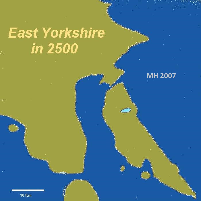
sea level rise due to global warming will counteract this. I predict that the
rate of coastal erosion will probably increase. Once the sea breaks through the
low cliffs in the Barmston area it will flood the Hull Valley and the
Hornsea-Withernsea-Easington island will face erosion from all directions.
Hornsea Mere. It is generally agreed that the meres of Holderness
originated as kettle holes, where a large block of ice remained in the boulder
clay and as it melted left a depression. However Hornsea Mere just seems too big
for me – could there have gravel or peat extraction there?
Filey
Brigg. If you go to Filey Brigg you will have noticed large blocks
of the sandy limestone that have beautiful trace fossils on them. The blocks are
stacked up in an imbricated fashion. I have seen this pictured in a geography
text book as being a natural feature caused by the prevailing current in the
North Sea. I have noticed that on the northern side of the headland the
exposures look very square. I wonder if this was actually a quarry with blocks
of the tough stone being removed for use (perhaps for Scarborough Harbour walls)
and the softer rock being stacked to one side because it was not wanted (like
the Grey Bed is discarded in Middlegate Quarry)?
You
might like to compare this paper with
G W Lamplugh’s 1898 Open Questions lecture.
Copyright - Hull Geological Society 2022
Registered Educational Charity No. 229147