
Humberside Geologist no. 15
Tectonic structures in the Chalk of the northern part of the Yorkshire Wolds.
By Derek J. Gobbett
The Chalk of the Yorkshire Wolds is typically gently dipping and forms an open-flexed syncline plunging east-southeast (Versey 1948). Locally however, it is dramatically deformed into monoclinal folds striking east-west and often cut by strike faults. These structures lie en echelon and are confined to an east-west trending zone across the northern Wolds which has been referred to by Kent (1980) as the Howardian-Flamborough Fault Belt. The dramatic coastal cliff exposures at Selwicks Bay and Staple Nook have recently been described in detail (Starmer 1995, 2008) but there are also a number of smaller inland exposures which are less well documented (Fig.1).
I propose to review these structures and to discuss their development. The following descriptions are ordered roughly from west to east.Wright and Wright (1942) listed and numbered pits on the Wolds exposing the Chalk. These are referred to below as WW.
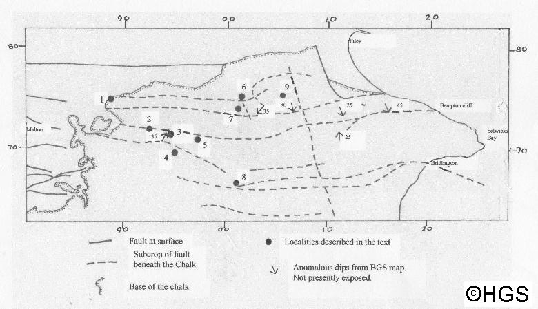
Fig.1. Map to show the relationship of the localities described to the sub-surface faults of Kirby and Swallow (1987). Ten kilometre grid squares shown marginally.
Descriptions of the structures
1. Knapton [SE 8850 7490].
This large quarry has now sadly become a landfill site. When it was being worked it exposed an excellent section through the Ferriby and Welton Formations of the Chalk with some Hunstanton Formation and Speeton Clay visible in the lowest part of the pit. The structure here is interpreted as a south-facing faulted monocline, the steep limb dipping south at 75o (Fig.2)
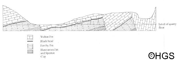
Fig. 2. Sketch section through Knapton Quarry. Approx. 250 m long and 40 m high
2. Haverdale [SE 9265 7175].
A small rather overgrown pit exposing flinty Chalk dipping south at 70o.
3. Haverdale east [SE 949 713].
This pit exposes more or less flat-lying, thin-bedded Chalk disturbed by minor faulting and folding. The main fault dips 60o east and slickensides on its surface pitch at 25o to the north and indicate a dextral normal movement.
4. Croome Dale [SE 9505 6990]. WW 86.
A disused pit which exposes horizontal flinty Chalk of the Burnham Formation. The quarry face runs north-south and although it is now obscured by rubbish fill, a north dipping shear zone was exposed ramping up to the south through horizontal chalk at 45o (Fig.3a) and then flattening to about 15o. The shear zone has a width of 45 cm and clearly shows reverse movement. Below the hanging wall the thin-bedded Chalk has been dragged into disharmonic folds and modified by pressure solution. It passes down into breccia above the foot wall (Fig.3b).
Fig. 3a. Shear zone in Croome Dale pit.
Fig. 3b. Enlargement of square in 3a.
The amount of movement is not easy to ascertain as there is no obvious marker bed but the dislocation of flint layers indicate a minimum throw of 60 cm. The Chalk in the vicinity of the shear is not hardened.
5. Weaverthorpe [SE 9765 7095]. WW 87.
The north side of this pit exposes vertical Chalk of the Burnham Formation striking east-west. Slickensides on the bedding planes show that the beds young to the north and are thus part of a north-facing monocline. The southern side of the pit has a small exposure of Chalk dipping gently south. The two exposures must be separated by an east-west fault running along the quarry floor. This pit may be that figured by Daykins and Fox-Strangways (1886, Figures 7).
Vertical Chalk is exposed about 1 000 m to the west at SE 9630 7105 and was also recorded by Wright and Wright (1942) in another pit at SE 9785 7080 (WW88) which is now completely overgrown.
6. Gantondale [TA 0155 7490].
The B1257 road just north of Gantondale House was widened in 1987 and a new cutting made which exposed deformed Chalk. Unfortunately, according to the engineer in charge, no records were kept of the sections. The cutting is now overgrown but some of the structure at the base of the section can be interpreted. The extant features are illustrated in Fig. 4. The Chalk is here noticeably indurated and veins of coarse calcite are common.
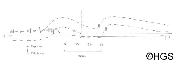
Fig.4. Roadside section at Gantondale, view ENE.
7. Foxholes [TA 0125 7355]. WW 102.
The disused quarry just north of Foxholes village exposes Burnham Formation (probably Lower Hagenowia rostrata Zone). Here the steep limb (dipping 70o) of a north facing monoclinal fold displays minor disharmonic folds, similar in style to those of Staple Nook. On the south side of the quarry a fault zone dipping south at 65o separates this limb from sub-horizontal Chalk dragged up against the fault (Fig.5). Slickenslides show that the fault movement is dextral-normal. (Starmer 2008, p.103).
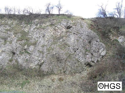
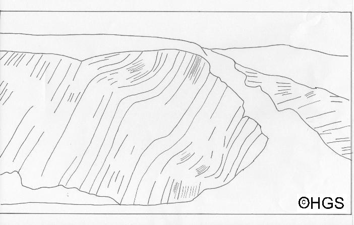
Fig. 5. Foxholes quarry, view east. Fault gulley shown by thick black line.
8. Langtoft [TA 0120 6595]. WW 92,
This disused quarry shows the base of a south-facing monoclinal flexure in the Chalk dipping 40o south flattening into sub-horizontal chalk to the south. No sign of this structure is seen in the adjacent quarry at TA 0120 6610 and a new section opened at TA 0140 6650 also shows undisturbed horizontal Chalk.
9. Fordon Bank [TA 0585 7510].
Thin-bedded Chalk is patchily exposed towards the top of the steep valley side. It strikes 256o and dips north at angles varying from 52o to 90o. It is cut by thin veins of coarse calcite striking north-south. Blocks of coarse calcite lie on the surface to the southeast around TA 0610 7500.
In addition to these localities the British Geological Survey 1:50000 map sheets 54 and 55 show anomalously high dips in the Chalk at several other inland localities. Some of these high dips, which are located on steep unstable slopes, are due to rotational slides. At other localities (Fig.1) they are probably tectonic, but these no longer show any exposed Chalk.
Discussion
The structures described above overlie a zone of mainly east-west striking faults affecting the Jurassic rocks of the Howardian Hills and the Lower Cretaceous Speeton Clay to the north of the Wolds escarpment. This fault zone is recognised as a hinge between the relatively stable Market Weighton Block to the south, which forms part of the East Midlands Shelf and the Cleveland Basin to the north (Kent 1980). Subsidence of the Cleveland Basin initiated normal faulting along its southern margin and the synsedimentary nature of this, at least in the Early Cretaceous, has been shown by Kirby and Swallow (1987). Seismic studies of the pre-Upper Cretaceous basement of the Wolds shows that the E-W trending faults of the Howardian Hills continue to the east and eventually swing southeast to merge with the Dowsing Fault line (Cameron 1992).
During the Late Cretaceous, subsidence appears to have slowed or ceased altogether and the Chalk Group was laid down over the whole area. Tertiary uplift of the Pennines and inversion of the Cleveland Basin has caused the total erosion of the Chalk from these areas and it is preserved only in the Wolds. The structures described here are post-Cretaceous and are most probably genetically related to these later movements. As can be seen in Figure 1, the subcrop of these faults underlies more or less directly the main localities of Chalk deformation described above and can be explained by further post-Cretaceous movement on those faults which in places extended them up into the overlying Chalk. However the main effect on the Chalk cover seems to have been to drape it over the fault planes to produce the north and south-facing monoclinal folds which characterise the northern Wolds (Fig.6).
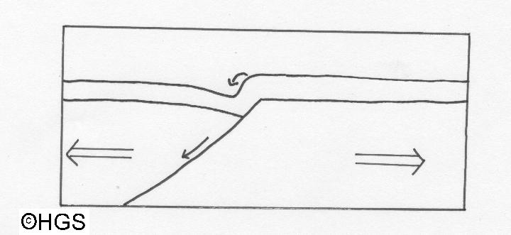
Fig. 6. A simple diagram to show how a monoclinal fold may be formed above a listric fault in the basement which is undergoing tensional stress. The top arrow indicates gravity collapse of the monoclinal crest. Similar monoclinal folds may also be produced under compressive stress.
It is unlikely that there was any appreciable Tertiary cover to the north of the Humber and the Yorkshire Chalk was never buried to any great depth so it was never under a great confining pressure. The kinematics of the folding in the Chalk would appear to be dominated by bedding plane slip producing concentric folds. Such movement could have been lubricated by thin marl bands between the beds. This thin-skinned tectonics or plis de couverture is present, albeit on a larger scale in the folded Jurassic to Lower Tertiary of the Purbeck monocline where faults in the Hercynian basement were re-activated in the mid Tertiary. Here, however, under a relatively thick Tertiary cover, the Chalk in the vertical limb between Bats Head and Lulworth Cove has slipped along multiple shears to accommodate the flexure (Arkell 1947; Phillips 1964).
The monoclines of the Yorkshire Wolds display smaller wavelength disharmonic folds in the more thinly bedded Chalk, notably at Foxholes and superbly in the Bempton cliffs. I think these may be caused by gravity collapse of near surface Chalk over the crest of the monocline. Again there is a comparable example in the Purbeck monocline at Stair Hole, Lulworth, where the Purbeck Beds are folded into the Lulworth Crumple, a structure attributed to gravity collapse by Phillips (1964).
References
Arkell, W.J. 1947. The geology of the country around Weymouth, Swanage, Corfe and Lulworth. Memoirs of the Geological Survey of Great Britain. 386pp.
Cameron, T.D.J. 1992. United Kingdom offshore regional report: the geology of the southern North Sea. London: HMSO for the British Geological Survey. xii + 156 pp.
Dakyins, J.R. and Fox-Strangways, C. 1886. The geology of the country around Driffield. Memoirs of the Geological Survey, 24pp.
Kent, P.E. 1980. Subsidence and uplift in East Yorkshire: a double inversion. Proceedings of the Yorkshire Geological Society, 42, 505-524.
Kirby, J.A. and Swallow P.W. 1987. Tectonism and sedimentation in the Flamborough Head region of north-east England. Proceedings of the Yorkshire Geological Society, 46, 301-9.
Phillips, W.J. 1964. The structures in the Jurassic and Cretaceous rocks on the Dorset coast between White Nothe and Mupe Bay. Proceedings of the Geologists' Association. 75, 373-405.
Starmer, I.C. 1995. Deformation of the Upper Cretaceous Chalk at Selwicks Bay: its significance in the structural evolution of north-east England and the North Sea basin. Proceedings of the Yorkshire Geological Society, 50, 213-228.
Starmer, I.C. 2008. The concentration of folding and faulting in the Chalk at Staple Newk (Scale Nab), near Flamborough, East Yorkshire. Proceedings of the Yorkshire Geological Society, 57, 95-106.
Versey, H.C. 1948. The structure of east Yorkshire and north Lincolnshire. Proceedings of the Yorkshire Geological Society, 27,173-191.
Wright, C.W. and Wright, E.V. 1942. The Chalk of the Yorkshire Wolds. Proceedings of the Geologists' Association, 53, 122-127.