
Humberside Geologist No. 14
Coastal Erosion and the Lost Towns of Holderness.
By Gordon Ostler.
In this short project I will give a brief description of the original coastline of East Yorkshire, and a brief description of the changes that happened and why they happened. I will also give a short account of the towns and villages that were lost to the sea, because of the erosion.
Approximately two million years ago, the coastline of what is now East Yorkshire was a chalk cliff at the eastern edge of the Yorkshire Wolds. The cliff ran from Flamborough through Beverley and Hessle.
Holderness as we know it was a shallow bay, before the Ice Age of two million year ago, which deposited two tills: the Withernsea Till and the Skipsea Till. When the Ice Sheet retreated approximately ten thousand years ago, it left behind Boulder Clay (Till), which is made up from fine silts, boulders, from which it gets its name, gravel, and fossils. The new Boulder Clay cliffs are very unstable and subject to slumping due to rain and wave action. When the clay is wet it has butter-like consistency and this allows it to flow. Because of the slumping of the cliffs onto the beach, the sea is able to wash the clay particles away leaving behind erratics. These erratics provide evidence for the area the Ice Sheet covered.
The erratics washed out of the cliffs can be found on the beach. There is material from Scotland, the Lake District, Yorkshire, Denmark, Norway and Sweden. They include fossils and jet from Whitby, volcanic rock from Scotland, green stone (volcanic tuff) from the Lake District, larvikite from Norway, and gneiss. However, one does have to be careful when identifying larvikite and gneiss, as being brought down and deposited by the Ice Sheets, because in recent years a lot of sea defences have been built from large blocks of larvikite and gneiss. The safe way, when identifying them, as evidence of the Ice Sheet, is to only accept those samples taken from the cliff face and not those from the beach. Other evidence for the movement of the Ice Sheet are rocks that have striations (lines and grooves) on them; these striations are evidence of the rock being pushed and dragged against other material.
The slumping of the cliffs and the washing away of the material by the sea has been going on from when the Till was first deposited. It has been estimated that a strip of land approximately three and a half miles wide has been washed into the North Sea from the Holderness Coast since the time the Romans occupied Britain (Barbara English 1991). George de Boer (1964) estimates that two miles of the coast has been lost since the Norman invasion in 1066 AD. Unless modern engineers can come up with some plan to stop the erosion, the sea will eventually take the Holderness coastline back to the original chalk cliffs of the Yorkshire Wolds.
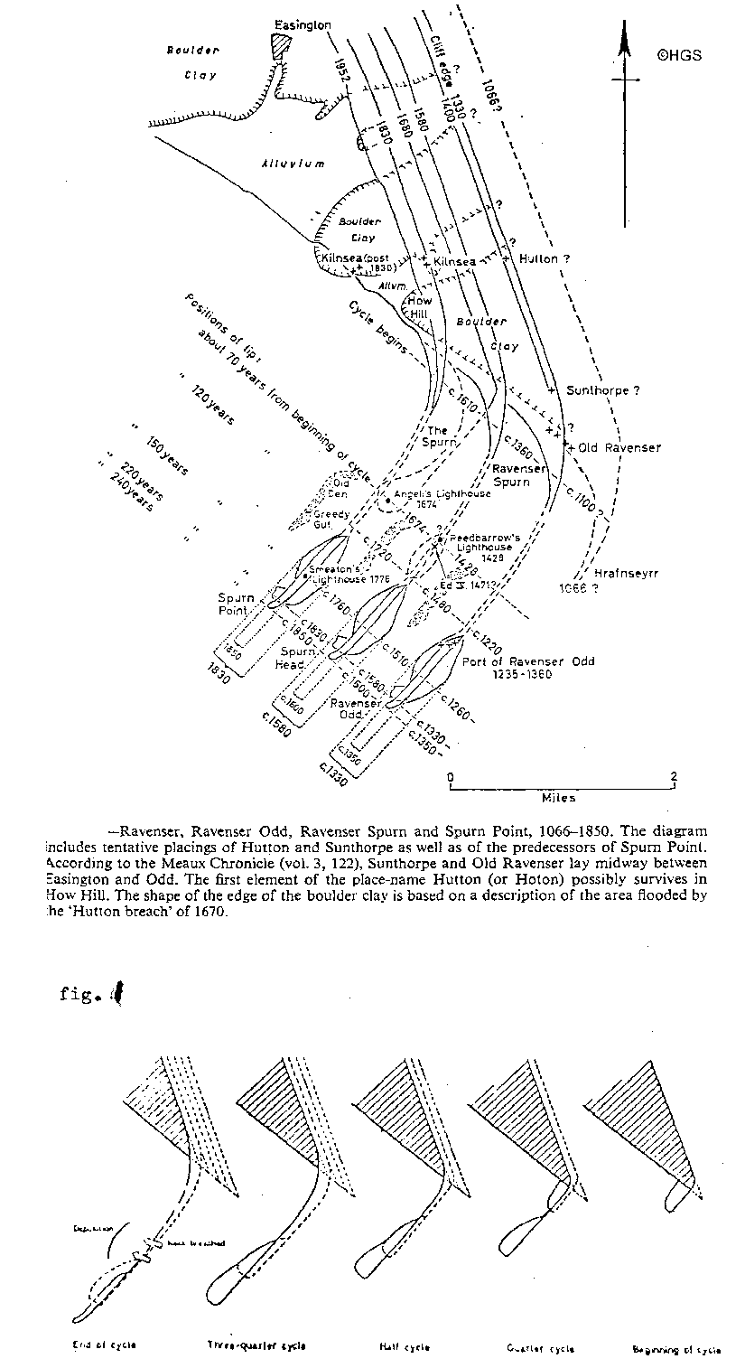
However, the clay material washed out is not totally lost to the sea; some of it is re-deposited on the Lincolnshire coast and some of it forms the Spurn Peninsula. The Spurn Peninsula has an interesting history. It is currently being eroded and there will be a breaching of the spit; the tip of Spurn will become an island once again, as it has done many times in the past. George de Boer has made a detailed study of it and has produced a very detailed plan of the 250 years cycle he believes the peninsula goes through, and the possible locations of the previous spits (see fig. 1). He clearly shows that with each cycle the peninsula progresses westward. De Boer (1964) and English (1991) suggest that when the material that forms the spit at the Humber mouth grows too large for the mouth to support, the pressure of the water from the river and the wave action of the North Sea become too great for the loosely bonded material to hold back the incoming tides which eventually breach it.
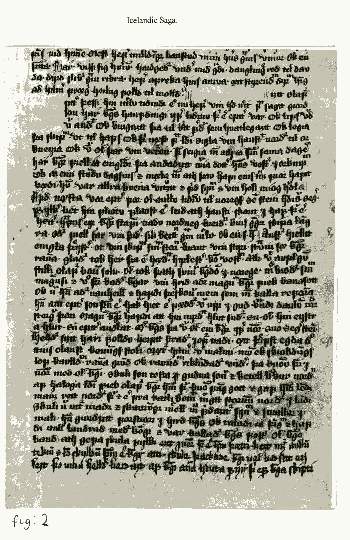
Most of the information about the lost towns and villages of the Humber Estuary comes from the works of Abbot Burton (1393-99 AD) of Meaux Abbey, East Yorkshire. In the Chronica Monasterii de Melsa, he names towns and villages lost to the sea. There are, however, other documents, which tell us of their existence, for example, the Icelandic Sagas tell the story of Harold Sigurdson sailing from Hrafnreyri (Ravenser) (see fig. 2). The earliest English post-conquest, of 1066, is possibly in the Pipe Role of 1230, which names Ravenser. William Shakespeare's Richard II, act 2, scene 1, also speaks of Ravenspurg (Ravenser).
Towns and villages lost include:-
In J. R. Boyle's Lost Towns of the Humber (1889) there is a facsimile of the ruins of Burstall Priory drawn by Buck in 1721; it was lost to the sea also. In 1822 there were thirty houses and a church listed for Kilnsea. By 1826 the sea had reached the church and it finally fell into the sea. When the "'Blue Bell" Inn at Kilnsea was built in 1847 a wall plaque states it was 534 yards from the sea. In 1989 the inn was 217 yards from the sea, in 1994 it was 190 yards, and on the 17th May 2004 it was 160 yards from the sea.
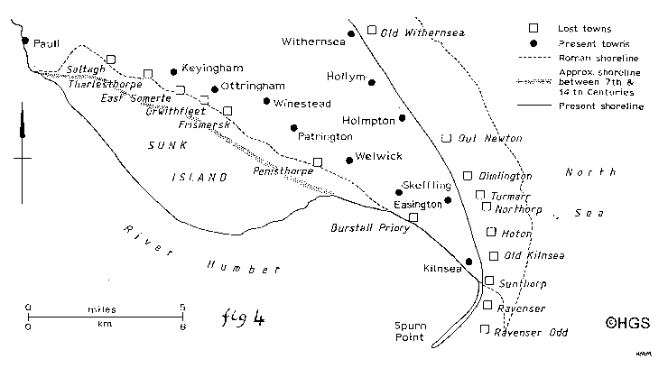
Those villages named above were located on the Humber banks; there are numerous towns and villages lost from the East coast of Yorkshire itself, for example, Old Withernsea, Out Newton, Dimlington, Turmarr, Northorp, Hoton, Old Kilnsea, Sunthorpe (see fig. 3, drawing by Wendy Munday).
I believe that there are very severe consequences for the people of Holderness arising from the erosion that is happening on the East Coast. Major towns and cities, for example Beverley and Hull, will be washed away as will some of the best farmland in the country.
Bibliography
de Boer G, 1964. Spurn Head: its history and evolution Trans. Inst. Br. Geog. 34, 71-89.
Boyle J R, 1889. Lost Towns of the Humber. A Brown & Son, Hull.
Abbot Burton, 1369-99. Chronica Monasterii de Melsa
English B, 1991. Ravenser Odd, A lost East Yorkshire town. Chap 10 , pp 149-155 of D B Lewis (ed.) The Yorkshire Coast, Normandy Press.
Ostler G, 1990. Lost Villages Of The Humber Estuary. Local History Archives Units, Hull College of Further Education, Hull.
Shepard T, 1912. The lost towns of the Yorkshire coast. Reprinted 1986, Mr Pye Books, Howden.
Acknowledgements
The staff of Hull City Local History Library.
The staff of the Royal Library, Copenhagen, Denmark, for their help tracing the Icelandic Saga
The staff of Stofun Arna Magnussor A Islandi Arnagori Vio Suourgtu, 101, Reykjavik, Iceland, for providing me with a photograph of the Icelandic Saga, and allowing it to be reproduced.
George de Boer for allowing the reproduction of his plan of Spurn, in Lost Villages Of The Humber Estuary.
Agnete Loth, Det Amamagnaenske Institut, Kobenhavns Universitet Amager, Denmark, for her help in obtaining a photograph of the Icelandic Saga.
Wendy Munday for allowing the reproduction of her map, in Lost Villages Of The Humber Estuary.
(c) Hull Geological Society 1999 + 2007
copyright Hull Geological Society 2020