Hull Geological
Society

Lost and found: the
pre-Skipsea Till palaeo-valley fill sediments of Flamborough Head rediscovered.
by
I. Heppenstall
et al.
[Draft text,
Version 2B, November 2010]
1. Introduction.
In 2001 as part of a project to investigate the
possibility of additional sites of last interglacial (Marine Isotope Stage (MIS)
5e) age in the vicinity of the classic section at Sewerby (SY) Ian Heppenstall
first investigated the sections at Danes’ Dyke (DD) and South Landing (SL), on
the southern shores of Flamborough Head, (references). This initial work clearly
demonstrated the presence of suites of chalk rich gravels at both DD and SL that
appeared to be the oldest sediments filling palaeo-valleys cut into faulted
chalk bedrock. As the sites appeared to be of significance to the Pleistocene
history of the headland, the Flamborough Quaternary Research Group (FQRG) of the
Hull Geological Society (HGS) was set up in 2002 to progress research on the
three sites and to work more widely on the Pleistocene record of Flamborough
Head, which has received little attention in comparison with the much better
known glacigenic sequences of Holderness to the south (references).
Briefly describe the location of all
three sites (Fig. 1, location map).
Brief literature review pertinent to the
sites. Mention of Dakyns (1880), Lamplugh (1890 and 1891) and other relevant
work of more than just historical interest.
Note potential value of the sites to a) understanding of the history and
processes of valley development on the Yorkshire Chalk during the Pleistocene
and b) the chronology of glaciations in East Yorkshire (particularly within the
Dimlington Stadial of the Devensian Stage) and more widely in eastern England
(references).
2.
Methods.
The
Pleistocene sediments at all three of the sites have been studied in detail over
the last 9 years and the work continues. Repeated visits have been made to the
sites to record the stratigraphy as the sections change due to slumping of the
superjacent glacigenic sediments and sporadic marine erosion of the cliff base.
Access to some parts of all of the sections is difficult due to slumping and the
steepness of the cliffs and so a photographic record has also been maintained to
document the changing state of the exposures and to capture important outcrop
information that may only rarely be visible.
Sections
at the sites have been measured in detail and the sediments described and
logged. Bulk samples have been taken for particle size and clast lithological
analysis with which to characterise the sedimentary units present. Much of the
work been directed at the chalk rich gravels and sands forming the basal units
of the sedimentary sequences at both DD and SL. The overlying glacigenic
assemblages at both sites are complex (composed of numerous units of diamicton,
gravels and sands, and laminated sands, silts and clays) and have yet to be
described in detail. Partly this is due to the difficulty of access to the
cliffs and the constantly changing state of exposure in these units which are
very prone to slumping.
This work is now underway and will be reported
once work is complete.
3.
The rediscovered sites on Flamborough Head
3a. Danes’ Dyke.
Describe the location of the palaeo-valley form. ?tectonic control of the
location.
Sediments (Description and interpretation). Need
min-max thicknesses of units.
1. in situ
Chalk bedrock (Flamborough Formation; Santonian Age; Uintacrinus socialis
biozone)
2. periglacially deformed chalk containing
cluster of hard (?Carboniferous) sandstone boulders (significance)
3. chalky gravel with silt rich matrix
(suggested informal stratigraphic name “Dykes End Silty Gravel). Gelifluction
deposit with loessic silt matrix and descrete loessic silt interbeds (cf.
Sewerby and Eppleworth)
4. Coarsening upward sequence of laminated
silts/clays to laminated/ripple cross laminated fine/medium sands. Probable
glaciolacustrine sediments.
5. Glacigenic assemblage of diamictons,
gravels and sands to surface.
3b.
South Landing.
Due
to the complexity of the sequences at South Landing the sediments at three
locations in the cliffs will be described to characterise the sediments and
stratigraphy of the valley fill. Again note likely tectonic control on the
location of the palaeo-valley.
South
Landing East.
From the East Nook
headland to Quay Hole (a.k.a. Key Hole)
1. Chalk bedrock (Flamborough Formation; Santonian
Age; “Hagenowia rostrata” biozone)
2. in
situ but brecciated chalk
3. Chalk rich (erratic poor) gravels and
sands. Note sedimentological and internal stratigraphic details. Suggested
informal stratigraphic name for this unit – “Quay-Hole Gravels and Sands”. Sharp
erosive (glacial?) top to the unit here.
4. Glacigenic assemblage. Includes a basal
sand, diamictons , chalky gravels, possible “raft” of “Basement Till” and shelly
clay/sand. (references Lamplugh 1890 and Catt 1963, 2007).
South
Landing Central.
Between Quay
Hole and the present valley
Base of sequence not seen.
3. Chalk rich (erratic poor) gravels and
sands. Note sedimnetological and internal stratigraphic details. “Quay-Hole
Gravels and Sands”. Chalky gravels
appear to extend higher in the section here. Rafted in part???
South
Landing West.
From
the present valley to West Nook
1. Chalk bedrock. (Flamborough Formation; Santonian Age; “Hagenowia rostrata”
biozone)
Note valley cut/cliff to the immediate west of the section. Subhorizontal
platform of chalk beneath the deposits. ~ 2m OD (educated guess!). Above modern
shore platform in chalk.
2. Chalk rich, erratic rich, gravels and more
obviously quartz rich sands. Suggested informal stratigraphic name – “West Nook
Gravels and Sands”. Note imbrication of clasts and low angle
cross-stratification in some sand beds. ?iron pan in lowermost beds. Large
?Jurassic sandstone boulder on chalk at base of unit. Significance? Clast size
tends to diminish upward. Cryoturbated horizon towards the top of the unit –
overlain again by beds with flat lying clasts. Upper beds of the unit are
cemented by carbonate to form a conspicuous ledge in the face. These upper beds
seem to have much more angular chalk clasts some of which appear to have also
been ?frost shattered in situ and the cracks filled with matrix sand. Discuss interpreted
relationship of these gravels and sands to the Key-Hole Gravels and Sands.
3. Glacigenic assemblage. Complex and relatively
poorly exposed. Commences with a sequence of laminated sands and silts/clays.
These are overlain by diamictons and gravels/sands to the surface.
4. Discussion, ?Summary.
Significance
of the sites. Ongoing research by the FQRG of the HGS and future research
potential of the sites and the Flamborough Head area.
Chronology of
the Dimlington Stadial glacigenic sediments in East Yorkshire and further afield
etc etc
5. Acknowledgements.
All
members (names to be included) of the HGS FQRG who have contributed to the
project over the last 9 years. Alastair Gemmell and Audrey Innes (University of
Aberdeen) for undertaking the particle size analyses to aid characterisation of
the sediments. Ian Candy (Royal Holloway University of London) for his work on
the carbonate cements in the West Nook Gravels and Sands. Lynda Howard for
searching sediment samples for chironomids. Mark Bateman and John Wainwright
(University of Sheffield) for visiting South Landing and collecting samples for
OSL dating. John Catt for discussions in the field on a joint HGS/ Yorkshire
Geological Society field trip in 2009. Colin Whiteman and John Boardman for
helpful comments on the sediments. The Geography Department, University of Hull
for their hospitality in allowing meetings of the FQRG to be held there.
6.
References. To
be pruned or added to as necessary.
Bateman,
M.D., Buckland, P.C., Chase, B., Frederick, C.D. and Gaunt, G.D. (2007). The
Late-Devensian proglacial lake Humber; new evidence from littoral deposits at
Ferrybridge, Yorkshire, England. Boreas,
37, 195-210.
Bateman,
M.D., Buckland, P.C., Frederick, C.D. and Whitehouse, N.J. (eds). (2001).
The Quaternary of East Yorkshire and North
Lincolnshire. Field Guide. Quaternary Research Association, London.
Bateman,
M.D. and Catt, J.A. (1996). An absolute chronology for the raised beach and
associated deposits at Sewerby, East Yorkshire, England.
Journal of Quaternary Science,
11, 389-395.
Benn,
D.I. and Evans, D.J.A. (1968). Glaciers
and glaciations. Arnold, London.
Boston,
C.M., Evans, D.J.A. and Ó Cofaigh, C. (2010). Styles of deposition at the margin
of the Last Glacial Maximum North Sea lobe of the British-Irish Ice Sheet: an
assessment based on geochemical properties of glacigenic deposits in eastern
England. Quaternary Science Reviews.
doi:10.1016/j.quascirev.2010.05.028
Boylan,
P.J. (1967). The Pleistocene Mammalia of the Sewerby-Hessle buried cliff, East
Yorkshire. Proceedings of the Yorkshire
Geological Society, 36, 115-125.
British
Geological Survey. (1985). Flamborough and
Bridlington. England and Wales Sheets
55 & 65. Solid and Drift
Geology. 1:50 000 Provisional Series. British Geological Survey, Keyworth,
Nottingham.
Catt,
J.A. (1963). Stratigraphical
investigations in the Pleistocene deposits of Holderness, East Yorkshire.
Unpublished PhD Thesis, University of Hull.
Catt,
J. A. (2007). The Pleistocene glaciations of eastern Yorkshire: a review.
Proceedings of the Yorkshire Geological
Society, 56, 177-207.
Catt,
J.A. and Penny, L.F. (1966). The Pleistocene deposits of Holderness, East
Yorkshire. Proceedings of the Yorkshire
Geological Society, 35, 375-420.
Catt,
J.A., Weir, A.H. and Madgett, P.A. (1974). The loess of eastern Yorkshire and
Lincolnshire. Proceedings of the Yorkshire
Geological Society, 40, 23-39.
Clark,
C.D., Evans, D.J.A., Khatwa, A., Bradwell, T., Jordan, C.J., Marsh, S.H.,
Mitchell, W.A.and Bateman, M.D. (2004). Mapand GIS database of glacial landforms
and features related to the last British Ice Sheet.
Boreas,
33, 359-375.
Evans, D.J.A., Clark, C.D.
and Mitchell, W.A. (2005). The last British ice sheet: a review of the evidence
utilised in the compilation of the glacial map of Britain.
Earth-Science Reviews,
70, 253-312.
Dakyns,
J.R. (1880). Glacial deposits north of Bridlington.
Proceedings of the Yorkshire Geological and Polytechnic Society,
7, 246-252.
Dakyns,
J.R. and Fox-Strangways, C. (1885). The Geology of Bridlington Bay. Memoir of
the Geological Survey.
[Check. Mortimer suggests
chalk gravels at DD and SL are mentioned in the memoir.]
Evans,
D.J.A., Owen, L.A. and Roberts, D. (1995). Stratigraphy and sedimentology of
Devensian (Dimlington Stadial) glacial deposits, east Yorkshire, England.
Journal of Quaternary Science,
10, 241-265.
Evans,
D.J.A. and Thomson, S.A. (2010). Glacial sediments and landforms of Holderness,
eastern England: A glacial depositional model for the North Sea Lobe of the
British-Irish Ice Sheet. Earth-Science
Reviews, 101, 147-189.
Eyles,
N., McCabe, A.M. and Bowen, D.Q. (1994). The stratigraphic and sedimentological
significance of Late Devensian ice sheet surging in Holderness, Yorkshire, U.K.
Quaternary Science Reviews,
13, 727-759.
Farrington,
A. and Mitchell, G.F. (1951). The end-moraine north of Flamborough Head.
Proceedings of the Geologists’ Association,
62, 100-106.
Lamplugh,
G.W. (1888). Report on the buried cliff at Sewerby.
Proceedings of the Yorkshire Geological and Polytechnic Society,
9, 381-392.
Lamplugh,
G.W. (1890). On a new locality for the arctic fauna of the “Basement” boulder
clay in Yorkshire. Geological Magazine,
7, 61-70.
Lamplugh,
G.W. (1891). On the drifts of Flamborough Head.
Quarterly Journal of the Geological Society of London,
47, 384-431.
Lewis,
S.G. (1999). Eastern England. In:
Bowen, D.Q. (ed.) A Revised Correlation of
Quaternary Deposits in the British Isles. Geological Society of London,
Special Report No. 23, 10-27.
Madgett,
P.A. and Catt, J.A. (1978). Petrography, stratigraphy and weathering of Late
Pleistocene tills in East Yorkshire, Lincolnshire and north Norfolk.
Proceedings of the Yorkshire Geological
Society, 42, 55-108.
McCabe, A.M., Knight, J. and
McCarron, S. (1998). Evidence for Heinrich event 1 in the British Isles.
Journal of Quaternary Science,
13, 549-568.
Murton,
D.K., Pawley, S.M. and Murton, J.B. (2009). Sedimentology and luminescence ages
of Glacial Lake Humber deposits in the central Vale of York.
Proceedings of the Geologists’ Association.
doi: 10.1016/j.pgeola.2009.09.001.
Peacock,
J.D. (1997). Was there a readvance of the British ice sheet into the North Sea
between 15 ka and 14 ka BP? Quaternary
Newsletter, 81, 1-8.
Penny,
L.F. and Catt, J.A (1967). Stone orientation and other structural features of
the tills in East Yorkshire. Geological
Magazine, 104, 344-360.
Penny,
L.F., Coope, G.R. and Catt, J.A. (1969). Age and insect fauna of the Dimlington
Silts, East Yorkshire. Nature,
224, 65-67.
Penny,
L.F. and Rawson, P.F. (1969). Field Meeting in East Yorkshire and North
Lincolnshire. 29 July-9 August 1967.
Proceedings of the Geologists’ Assocaition,
80, 193-216.
Rose,
J. (1985). The Dimlington Stadial/Dimlington Chronozone; a proposal for naming
the main glacial episode of the Late Devensian in Britain.
Boreas, 14, 225-230.
Stather,
J.W. (1898). A buried valley in the Chalk near Flamboro’ Station.
Transactions of the Hull Geological
Society, 5, 11-13.
Straw,
A. (1979). The Devensian Glaciation. In:
Straw, A. and Clayton, K.M. (eds) The
Geomorphology of the British Isles: Eastern and Central England. Methuen,
London, 21-45.
Wintle, A.G. and Catt, J.A.
(1985). Thermoluminescence dating of Dimlington Stadial deposits in Eastern
England. Boreas,
14, 231-234.
Figures.
Fig.
1. Location map of the sites on Flamborough Head.
Fig.
2. Schematic stratigraphic logs of the sediments at DD and SL.
Any
others?
Possible
photographs
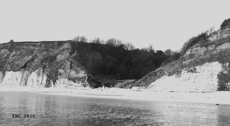
Fig.
X. The palaeo-valley form at Danes’ Dyke, Flamborough Head, East Yorkshire. View
looking NW. Note chalk forms the lower third of the cliffs overlain by
glacigenic sediments.
The
wedge-shaped unit of Dykes End Silty Gravels is present immediately west of the
modern valley form. Total cliff height is approximately 30m. (Photo: ERC).
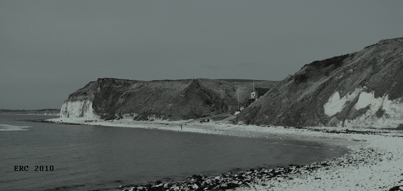
Fig.
Y. The palaeo-valley form at South Landing, Flamborough Head, East Yorkshire.
View looking W towards the interglacial cliff at Sewerby, north of Bridlington.
Note the chalk cliff to the west (left) defining that flank of the palaeo-valley
form. The white cliff to the right (east) is composed of chalk rich, erratic
poor, Key-Hole Gravels and Sands. Immediately to the left (west) of the slipway
the lower portion of the cliff is composed of the chalk and erratic rich West
Nook Gravels and Sands. Large blocks of calcreted gravels and sands can be seen
on the modern beach in front of the western section. A complex sequence of
glacigenic sediments overlies these older deposits. Total cliff height is
approximately 30m. (Photo: ERC).
Copyright
- Hull Geological Society 2025
Registered
Educational Charity No. 229147
Home