|

Humberside
Geologist No.12
Rifle Butts Quarry
SSSI
by Mike Horne and Cyril Dutton
|
Humberside
Geologist No.12
Rifle Butts Quarry
SSSI
by Mike Horne and Cyril Dutton
(click here for a revised
version of this paper)
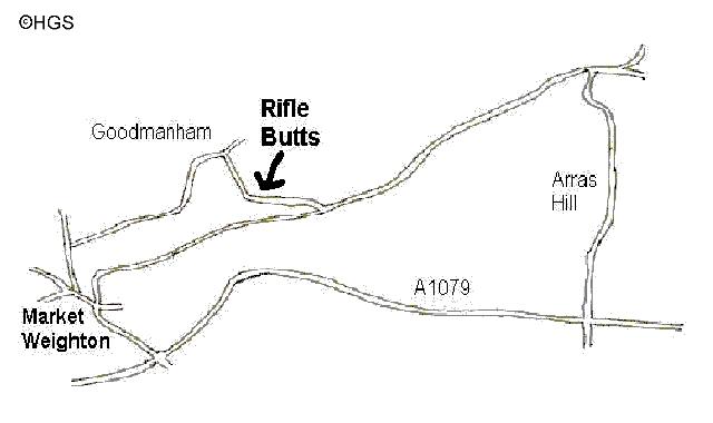
Rifle Butts is a small disused quarry near Goodmanham, East Yorkshire [NGR SE 897 427]. It lies at the bottom of the chalk scarp at the western end of the Goodmanham Channel, glacial spillway, which was cut by glacial meltwaters during the Ice Age.
Map for Rifle Butts SSSI
The quarry was opened in the 1860s to provide material for the building of the North Eastern Railway line from Market Weighton. It was later bought by a local farmer who then rented it to the local Rifle Club until the 1940s. Because geologists thought it to be of national importance the 0.3 hectare site was desibniated as a Site of Special Scientific Interest in 1952, and the designation has been confirmed in national reviews in 1981 and 1987.
The site was bought by the Yorkshire Wildlife Trust on June 30th 1964 and was excavated at that time by the Yorkshire Geological Society. A concrete retaining wall was built which can still be seen at the left hand end of the site. In 1987 a new and enlarged exposure was cut by the Nature Conservancy Council and Community Rural Aid. The Hull Geological Society informally adopted the site to help keep it clean and tidy. In 1993 a roof was erected over the exposure to protect it from rain and weathering. This project cost £6,500 and was funded by the Curry Fund of the Geologists' Association, English Nature and the Yorkshire Wildlife Trust.
Permission to visit the site must be obtained from the warden or the Hull Geological Society Secretary.
The site is a designated SSSI and Nature Reserve so please:
do not hammer, do not collect samples without permission and do not trample the plants.
There are three rock types exposed in the
quarry: Lower Chalk of the Ferriby Formation, Red Chalk (or Hunstanton Formation)
and Jurassic sediments. These rocks may be compared with other exposures in
the region, such as the cliffs at Speeton and Buckton North of Bridlington and
the quarries at Melton and South Ferriby, either side of the River Humber.
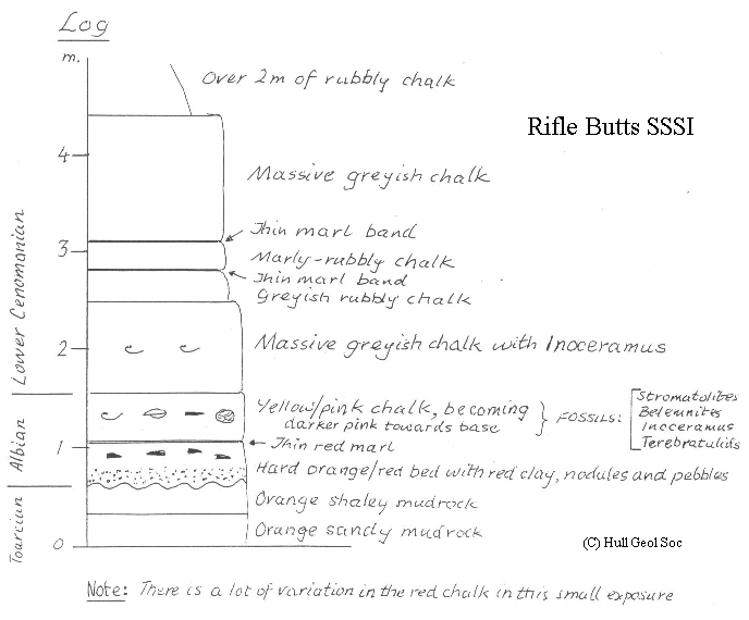
The Lower Chalk contains the same fossils
as the Lower Chalk at Buckton Cliff on the coast, and at South Ferriby. This
Chalk at Rifle Butts is the lowest part of the Ferriby Chalk Formation (Lower
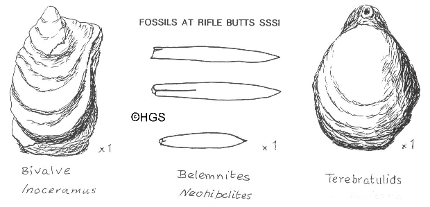
Chalk) and is of Cenomanian age. The Red Chalk contains fossil bivalves, brachiopods
and belemnites; similar ones can be seen in the Red Chalk at Buckton and South
Ferriby. The Red Chalk is about 2 metres thick at South Ferriby and is about
10 metres thick at Buckton; it is of Albian age (about 100 million years old).
The rocks beneath the Red Chalk at Buckton and South Ferriby are different. At Buckton there is the Speeton Clay (Lower Cretaceous, dated from 113 to 144 million years old) with Kimmeridge Clay (Upper Jurassic, about 155 million years old) below it. At South Ferriby there is a thin layer of Carstone (Mid Cretaceous, about 119 million years old) with some Kimmeridge Clay (Upper Jurassic, about 155 million years old) below. Fossils have not been found in the beds beneath the Red Chalk at Rifle Butts, but recently a fossil ammonite, Dactylioceras tenuicostatum, was found beneath the Red Chalk on the Market Weighton by-pass (less than 2km away) which is dated as being of early Toarcian age (about 194 m.y.).
You will find pebbles and phosphatic nodules at the base of the Red Chalk. You may also see fossil stromatolites (a mass of calcareous sediment in thin layers). These are all indicators of shallow water deposition. The contact at the base is irregular, indicating that there has been a period of erosion of the underlying bed. By comparing the dates of the bed beneath the Red Chalk we can see that there has been almost continuous deposition at Buckton, a break of deposition of about 40 million years at South Ferriby and a break of deposition of about 80 million years at Rifle Butts. During the time gap that occurred at Rifle Butts nearly a thousand metres of sediments were deposited in the North Yorkshire Coast area. But these rocks have not been deposited at Rifle Butts, or if they were they have been eroded away. This implies that the area around Rifle Butts must have been above sea level for some or all of this time.
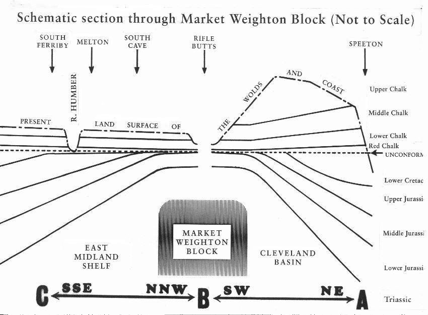
Geologists believe that there is a Structural High or Block running in an eastwest direction through the Market Weighton area (sometimes called the Market Weighton Axis) which affected the deposition of sediments during Jurassic times by acting as a barrier or island. It also affected deposition in Cretaceous times. The Speeton Clay is only found to the north of the High. The Albian Red Chalk is much thicker at Buckton and thickens to the south of the High. The Upper Cretaceous Chalk is relatively thinner in the Market Weighton area. Rifle Butts Quarry is important to geologists as it provides the evidence of this High as it exposes the greatest overstep in the region and is of fundamental importance for the palaeogeography of northern England.
Copyright Humberside Geological Society 1999
Click here for an updated version of the article
Return to Humberside Geologist