
EAST YORKSHIRE FIELD STUDIES
Number 2
first published 1969
An
Introduction to the Geology of Holderness with Special Reference to the
Coast
By
K.
Fenton
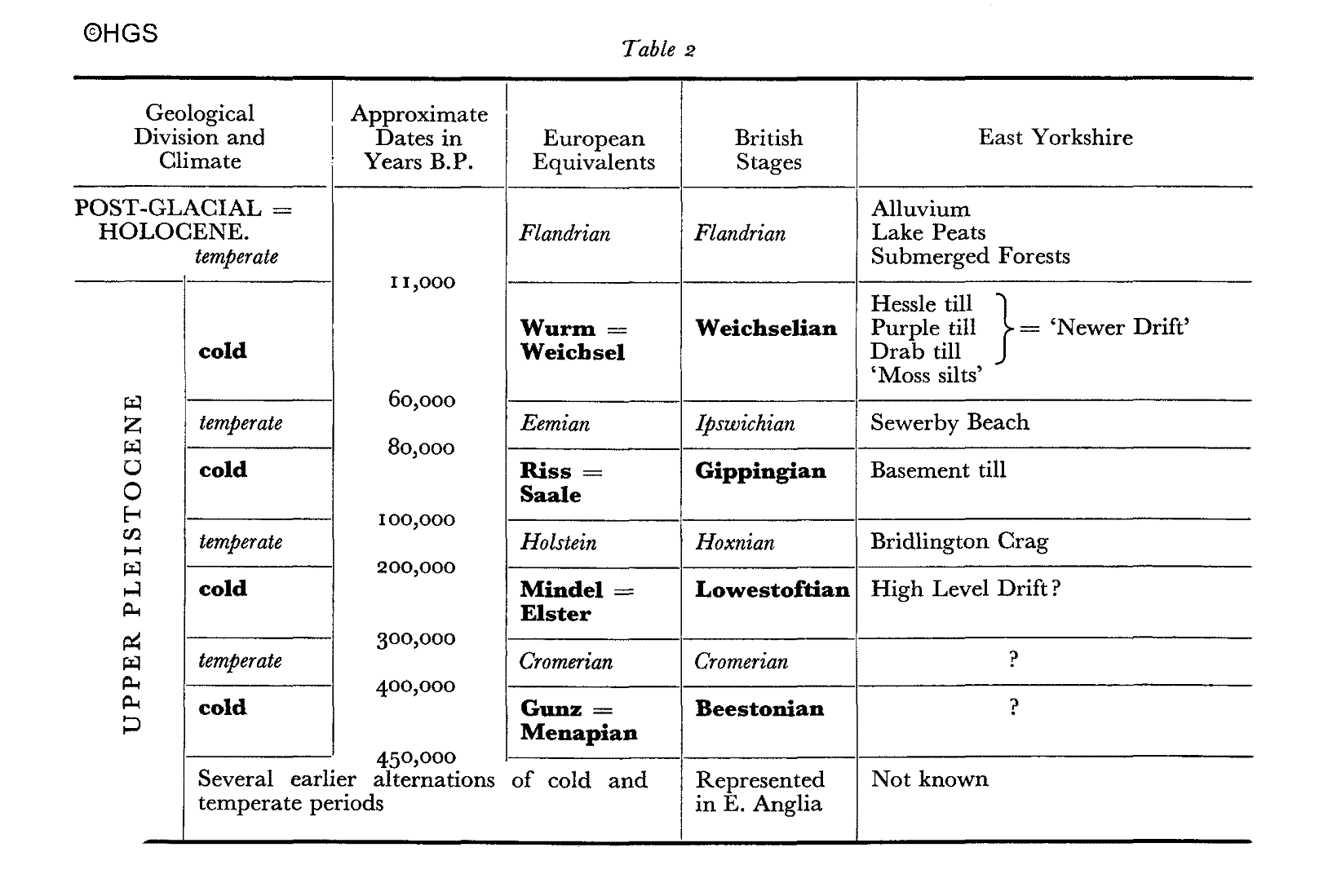
The Chalk of the Wolds extends in an arc from
Flam- borough Head to the
On a world-wide scale the geological evidence of
the events of the last one to two million years indicates a series of
climatic fluctuations of which in Britain the last three major cold periods
(see Table 2) or 'Glacials' with intervening temperate periods or
'Interglacials' are well represented, with evidence, in places, of some of
the earlier parts of the Pleistocene succession. The causes of these
fluctuations still remain as matters for speculation. It is also uncertain
whether or not they have ceased so that prevailing conditions may perhaps be
only another interglacial period. The principal areas of accumulation from
which the ice, because of its ability to flow, has travelled to Holderness
are
Soft clays and sands were rapidly digested within
the mass of moving ice and debris and so are unusual as erratics, but apart
from these there is a wide variety of rock-types which can be found within
the deposits or washed out on the beaches. Igneous rocks include many kinds,
varying from coarsely crystalline granites to porphyritic dyke rocks, vein
quartz and finely grained dolerites and basalts. Metamorphic rocks are
represented by gneisses and schists, and sedimentary rocks by various
sandstones, limestones and shales, septaria, pyrites, coal fragments, etc.,
(waterworn fragments of concrete, brick and glass on the beach may puzzle
the beginner). Derived fossils, (i.e., ones picked up as erratics from older
rocks) are very common, the most obvious being corals such as
Lithostrotion
from the Carboniferous, the nearly indestructible
Gryphaea, masses
of 'shelly limestone' and ammonites from the Lias, and belemnites and
echinoids from Cretaceous beds. The boulder clay or till is not a uniform
mass. Along the coast several distinct beds can be seen in the cliffs and on
the foreshore when, as occasionally happens, the sand is removed by the
action of the sea. Inland, apart from the surface layers, exposures are rare
and it is most regrettable that borings and excavations have not been
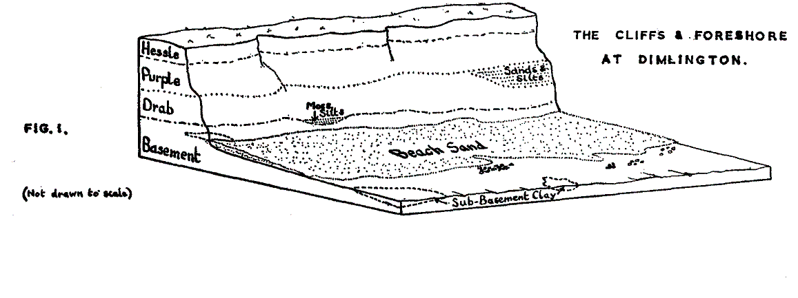
recorded in critical detail. At present four beds are recognised and all of
them can be seen at Dimlington where the cliffs exceed too ft. in height.
The sequence as seen above beach level is shown in Table 1 and Fig. 1. The
nomenclature used is that of Catt and Penny and differs in some details from
that used in earlier descriptions.
Table
i
|
Name of Till |
Approx. thickness |
Dominant colour
of matrix
|
|
5-15 ft. |
Foxy-red, sometimes yellowish |
|
|
Purple |
20-60 ft. |
Dark reddish brown |
|
Drab |
20-30 ft |
Dark chocolate brown |
|
Basement |
0-10 ft.
|
Grey-brown, distinct greenish tinge. |
Around Withernsea the cliffs are much lower and
only Purple and Hessle tills are visible, but between Aldborough and Hornsea
Drab till appears again in the cliffs beneath the two upper tills. There is
a characteristic 'red-band' within the Drab till which occurs just above
beach level. A re-appraisal of the relationship and extent of the Purple and
Hessle tills seems to be desirable in this area. North of Hornsea the cliffs
appear to contain only representatives of the Drab till and the upper few
feet have weathered to a brown colour with the fissures turning blue-grey
similar to the Hessle till in the south. That this coloration is the result
of weathering further strengthens the necessity of re-assessing the
distribution of the Purple and Hessle tills, the latter being perhaps more
of a weathering phenomenon than a true bed of till. Most of the Drab till in
the high cliffs to the north of Hornsea has a distinctly Drab-coloured
matrix but in texture and the small size of the erratics is curiously
different from that south of Hornsea. In one short stretch between Atwick
and Barmston, however, the texture and red-band characteristic of the
Mappleton area reappears. Here erratics are large and many of them are
strewn on the beach clearly marking the regional difference. Towards
Barmston the till occupies only the lower part of the cliff and disappears
beneath the beach altogether around Fraisthorpe. The upper part of these low
cliffs and the entire cliff from Fraisthorpe to Bridlington promenade
appears to consist, where not overgrown, of a mixture of distinctly varved
clays, banded silts, sands and gravels so that all this northern part of the
cliff could well be described as a predominantly melt- water area in marked
contrast to the tills of the southern part of the Holderness coast. At
Bridlington the cliffs, which were originally described in the last century,
are now covered by, the promenade. Occasionally, after scouring has cleared
away sand from parts of the north beach, Basement till can be seen. From the
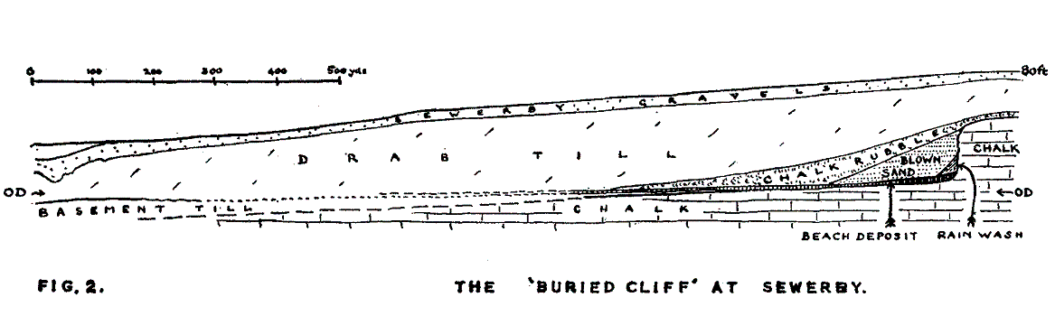
promenade towards Sewerby, Drab till occupies the cliff face except for the
top few feet of Sewerby gravels. These two beds extend over the chalk when
it appears in the cliffs.
Erratic rocks are present throughout the four beds
of till. Many show so-called 'ice-scratching' where they have been in
contact with other hard material during transport. Generally when elongated
rocks are examined in situ
they are found to be preferentially orientated
with their long axes parallel to the direction of the flow of the ice. This
is approximately from the north-east in Holderness. The distribution of the
various kinds of erratics in the four different tills is not uniform and a
careful re-assessment of the suites of erratics may well be a major factor
in constructing a satisfactory model of the ice-sheets which have covered
Holderness. Scandinavian erratics are most abundant in the Basement till
with some Chalk, black flint and Magnesian Limestone. Drab till is
characterised by an abundance of Chalk and flint with granites,
Carboniferous Limestone, Border and Scottish rocks. Scandinavian erratics
become infrequent in the higher parts. There is still Chalk present in the
Purple till as well as Border rocks but in the Hessle Till erratics are both
smaller and fewer in number. The distribution of the tills inland is
difficult to ascertain. Certainly in south Holderness and extending to the
flanks of the Wolds Hessle till appears to provide a surface covering but a
great deal needs to be known about the extent of all the tills.
I
In
order to analyse the relationship of the Holderness tills to the glacial
sequence observable elsewhere it is important to look for both key
statigraphical evidence and any fossil remains of plants and animals. The
latter in particular may provide decisive dates. As so much is hidden,
particularly along the coast where there are some
100 ft. of deposits
between beach level and the surface of the Chalk, are there any other
deposits beneath the Basement till? Such evidence as exists indicates that
none are present although the question should still be considered an open
one. On the other hand, bearing in mind the maximum southerly extent of
ice-sheets, pockets of quartzite pebbles found around 4-500 ft. on the high
About a century ago, prior to the building of the
promenade at Bridlington, masses of greenish sand containing glauconite and
a very large number of fossil shells were discovered and designated as
'Bridlington Crag'. On a few occasions since, when the sea has removed the
beach sand adjacent to the 'Pavilion', other patches of 'Crag' have been
exposed, as well as some blue clay. The last time was in 1964. This
material, being enclosed within the Basement till, apparently represents
'erratic' portions of an earlier
Perhaps the most important stratigraphical
evidence is an observation made in relation to the Sewerby cliff when
obscuring materials had been removed at some distance south of the 'buried
cliff'. It is reported that the chalky beach deposit extends over the
surface of the Basement till. This, with the 'Moss silts' of Dimlington,
demonstrates that the Basement and Drab tills belong to separate
glaciations. If this is so the Sewerby fauna belongs to the interglacial
between them. An alternative hypothesis is that the Basement clay could
belong to an even earlier glaciation. This is feasible if one considers how
present day erosive processes could continue to remove material as far back
as the 'buried cliff' and still, perhaps, leave some of the tills on the sea
floor. Critical evidence is apparently lacking. The dating of the Sewerby
fauna could be either that of the Hoxnian or Ipswichian interglacials.
Hippopotamus
and Didermocerus
hemitoechus are more indicative of the
latter. Following the interglacial conditions responsible for the cliff and
beach the sea-level would fall as ice accumulated to the north. Exposure of
the sea bed would provide conditions in which the blown sand could
accumulate and increasing cold would form the chalk rubble by solifluxion.
The fresh water pools and associated 'Moss silts' would form at about the
same time, prior to the advance of the ice-sheet. A radio-carbon dating of
the moss gives a time, about 18,000 B.P. (Before Present), corresponding
with the maximum of the last glacial.
This leads to the problem of the relationships of
the Drab, Purple and Hessle tills. The dating of the underlying 'Moss
silts', the widespread presence of
Mammuthus and the fresh surface topography
place these tills in the last glaciation. The absence of Drab till around
Withernsea may be accounted for by postulating its continuity in a
depression below present sea-level which may be associated with an earlier
Two hypotheses can be formulated to account for
the existence of the three super-imposed upper tills. First that the
ice-sheet front fluctuated, advancing and retreating, so that each till
represents a separate advance and the irregularities in their distribution
are accounted for by massive lobes developing in the areas concerned. The
extensive deposit of bedded silts at the top of the Drab till at Dimlington
and the ravines in the Drab till, now filled by Purple till, may have been
formed by melt waters of the first retreat; and sandy and gravelly bands
between Purple and Hessle tills by melt waters of the second retreat. Gravel
deposits such as that at Cottingham and others at the top of the cliffs in
various places along the coast may relate to the final retreat. On the other
hand disturbances at the junctions between the layers of till or other
viable evidence has not so far been reported. The alternative hypothesis is
that the ice-sheet was a complex one. Ice approaching from Scandinavia would
have other streams from
Selected Bibliography
BOYLAN, P. J. 1967. The Pleistocene Mammalia of
the Sewerby-Hessle Buried Cliff,
CATT, J. and PENNY, L. F. 1966. The Pleistocene
Deposits of Holderness,
CHARLESWORTH, J. K. 1957.
The Quaternary Era.
2 Vols.
EMBLETON, C. and KING, C. A. M. 1968.
Glacial and Periglacial Morphology.
WEST, R. G. 1968.
Pleistocene Geology and Biology.
Longmans.
ZEUNER, F. E. 1959. The Pleistocene Period.
Copyright Hull Geological Society 2016