Skipsea Withow Mere
2008
raw data.
We should end up with 6 sets of records (plus any results from subsequent visits) --
Note - the GPS readings were taken at different times using different handheld GPS recorders each with its own degree of error, so there will be some variation in the readings. For instance - the point at the south of the northern section is recorded as TA 18381 54628 on 18th May and TA18380 54623 on 19th July.
Fieldwork carried out Sunday 18th May
Notes - the fieldwork was carried out by three teams. Each team measured up and down from a horizontal string. Dennis did the GPS survey. Mike and Ros did the measurements from the north-south datum line. Dennis, Ros and Rodney measured the southernmost section. David, Tony and Tracy measured the section south of the stream. Gareth, James and Bruce measured the section north of the stream. Important - the southern and northern sections were measured using independent horizontal lines -- there might be a height difference between the two!
Mike's notes -- towards the northern edge of Mere there was a noticeable thin layer of charcoal and sand between the lake silts and the base of the peat. Slightly further north I found a well preserved freshwater mussel shell in the lake silts.
Dennis's notes from Skipsea -
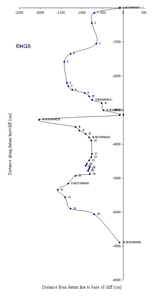
Below is some info that may be of use in preparing a report of the visit to the exposed bed of Skipsea Mere, (the bed). To enable an accurate plot of the plan view of the cliff to be drawn a reference line was placed between two small outcrops that just about framed the bed. The north end of the line was placed at the cliff bottom at a reference 18379/54651, (note, this and all other references can be prefixed with TA to denote the ordnance survey block). The south end was placed at the cliff bottom at 18393/54594. The compass bearing of the line was 345 degrees. Measurements, west to east, were taken from the line to the cliff at each significant change in the cliff contour and along the line, north to south, to record the position of the change. ( Ros has the measurements - see later)
Some other reference points were taken that may be of use to others in the field.
For the group working north of the stream, the northern end of your datum line was 18368/54631 and the southern end was 18381/54628. For the group working south of the stream, the northern end of your datum line was 18378/54620 and the southern end 18377/54605. The plan of the two datum lines can be deduced from the data collect to draw the plan from the north to the south outcrops. A small stream, land drain, intersects the bed and the reference at the drain outlet is 18369/54625 West of the bed, partially buried in the sand, is a field of large concrete blocks, mainly wartime anti tank blocks. The field is marked at the north east corner by an overturned pill box at location 18406/54626 and at the south east corner by another overturned pill box at location 18462/54520.
Dennis's notes of the southernmost section:-
Measured by Dennis Haughey, Ros Perry and Rodney Evans.
The cliff strata were measured at four points all to the south of reference 18377/54605 i.e. south of the southern logging team
Point 1 Reference 18414/54575 i.e. approx. 4 mtrs south of the southern team's southernmost log. Measurements going up from datum line 10cm black clay, 15cm dark sandy clay, 15cm black clay, 10cm sandy gravel, 5cm gravel, 35cm sand, 10cm gravel, 30cm sandy gravel, 20cm sandy gravel, this is similar to the previous bed but a definite layering is seen, 45cm sand, 10cm gravely soil and 40cm topsoil. Below the datum is boulder clay.
Point 2, (1 m north of point 1) Measurements going up from datum, 15cm black clay, 15cm gravel, 115cm sandy gravel,(landslip obscures detail), 10cm gravel, 40cm topsoil. Measuring down from datum, 5cm black clay, 15cm gravel, 2cm thin clay band, 8cm gravel, then boulder clay.
Point 3 (3 m north of point 1) Measurements going up from datum 5cm black clay, 2cm very shelly black clay, 30cm black with lots of sand and shell fragments, 50cm peat, 70cm top soil. Measuring down 5cm shelly black clay then an undetermined depth of black sandy clay.
Point 4 (3.5 m north of point 1) Measurements going up from datum 25cm sandy black clay with sparse shell inclusions, 60cm very woody peat, 80cm topsoil. Measuring down from datum, 35cm sandy black clay with sparse shell inclusions, 5cm gravel, then undetermined depth of black sandy clay.
===========
Tracy's record of the southern section:-
(Group: Tony Barker, David Baker & Tracy Marsters)
These logs were taken at the southern part of the exposure of the peat beds.
The horizontal was taken as 0cm. Beds above the horizontal were assigned positive numbers, those beds falling below the horizontal were assigned negative values.
Boulder clay was the top bed of every vertical log taken.
? in readings of pieces of wood found within the beds indicate unobtainable readings e.g. where the full length of the wood could not be seen.
Log at 0m
|
Bed |
Height of bed from the horizontal (cm) |
Overall thickness of bed (cm) |
Notes |
|
Boulder clay |
165 to 89 |
76 |
|
|
Woody peat |
89 to 14 |
75 |
Piece of wood (7x13x?cm) centred at 41cm. |
|
Black silt |
14 to -10 |
24 |
Piece of wood (3x4.5x?cm) centred at 12cm. |
|
Grey silt* |
-10 to -28 |
18 |
* bottom of grey silt bed not observable.
Log at 1m
|
Bed |
Height of bed from the horizontal (cm) |
Overall thickness of bed (cm) |
Notes |
|
Boulder clay |
158 to 64 |
106 |
|
|
Woody peat |
64 to -16 |
80 |
Hazelnuts found around the horizontal mark (i.e. 0cm). Piece of wood (5x9x?cm) centred at 4.5cm. |
|
Black silt |
-16 to -47 |
31 |
Piece of wood (5x4x?cm) centred at 17cm. Piece of wood (4x4x26cm) centred at 33cm.. |
|
Grey silt* |
-47 to -53 |
6 |
Layer of rounded stones located at intersection between this and the above bed. |
* bottom of grey silt bed not observable.
Grey silt bed no longer observable in any further log readings.
Log at 2m
|
Bed |
Height of bed from the horizontal (cm) |
Overall thickness of bed (cm) |
Notes |
|
Boulder clay |
157 to 61 |
96 |
|
|
Woody peat |
61 to 19 |
80 |
Hazelnuts and small (approx. 1cm long) pine cones found within this bed. |
|
Black silt* |
-19 to -80 |
61 |
* bottom of black silt bed not observable.
Log at 3m
|
Bed |
Height of bed from the horizontal (cm) |
Overall thickness of bed (cm) |
Notes |
|
Boulder clay |
147 to 53 |
94 |
|
|
Woody peat |
53 to 15 |
68 |
Piece of wood (6x13x?cm) centred at 45cm. Pine cones, seeds and dried berry/seed found within this bed. |
|
Black silt* |
-15 to -84 |
69 |
* bottom of black silt bed not observable.
Log at 4m
|
Bed |
Height of bed from the horizontal (cm) |
Overall thickness of bed (cm) |
Notes |
|
Boulder clay |
142 to 51 |
91 |
|
|
Woody peat |
51 to 7 |
58 |
|
|
Black silt* |
-7 to -94 |
87 |
* bottom of black silt bed not observable.
Log at 5m
|
Bed |
Height of bed from the horizontal (cm) |
Overall thickness of bed (cm) |
Notes |
|
Boulder clay |
141 to 53 |
88 |
|
|
Woody peat |
53 to 12 |
65 |
Pine cones found within this bed. |
|
Black silt* |
-12 to -103 |
91 |
* bottom of black silt bed not observable.
Log at 6m
|
Bed |
Height of bed from the horizontal (cm) |
Overall thickness of bed (cm) |
Notes |
|
Boulder clay |
144 to 56 |
88 |
|
|
Woody peat |
56 to 28 |
84 |
|
|
Black silt* |
-28 to -118 |
90 |
Pine cones and hazelnuts found within this bed. |
* bottom of black silt bed not observable.
Log at 7m
|
Bed |
Height of bed from the horizontal (cm) |
Overall thickness of bed (cm) |
Notes |
|
Boulder clay |
153 to 59 |
94 |
|
|
Woody peat |
59 to 30 |
89 |
|
|
Black silt* |
-30 to -112 |
82 |
Pine cones and hazelnuts found within this bed. |
* bottom of black silt bed not observable.
Log at 8m
|
Bed |
Height of bed from the horizontal (cm) |
Overall thickness of bed (cm) |
Notes |
|
Boulder clay |
158 to 56 |
102 |
|
|
Woody peat |
56 to 24 |
80 |
Hazelnuts found within this bed. |
|
Black silt* |
-24 to -106 |
82 |
Pine cones found within this bed. |
* bottom of black silt bed not observable.
Log at 9m
|
Bed |
Height of bed from the horizontal (cm) |
Overall thickness of bed (cm) |
Notes |
|
Boulder clay |
154 to 56 |
98 |
|
|
Woody peat |
56 to 28 |
84 |
|
|
Black silt* |
-28 to -115 |
87 |
Pine cones found within this bed. Piece of wood (13x18x?) centred at 59cm. |
* bottom of black silt bed not observable.
Log at 10m
|
Bed |
Height of bed from the horizontal (cm) |
Overall thickness of bed (cm) |
Notes |
|
Boulder clay |
142 to 44 |
98 |
|
|
Woody peat |
44 to 12 |
56 |
Piece of wood (8x2x?) centred at 7cm. |
|
Black silt* |
-12 to -100 |
88 |
Big piece of wood (36x14x?) centred at 56cm. |
* bottom of black silt bed not observable.
Log at 11m
|
Bed |
Height of bed from the horizontal (cm) |
Overall thickness of bed (cm) |
Notes |
|
Boulder clay |
152 to 40 |
112 |
Waste pipe (8x8.5x?cm) centred at 73cm. |
|
Woody peat |
40 to 33 |
73 |
Piece of wood (4x?x53cm) centred at 8cm. Piece of wood (6x?x80cm) centred at 10cm. Pine cones found within this bed. |
|
Black silt* |
-33 to -86 |
53 |
* bottom of black silt bed not observable.
Log at 12m
|
Bed |
Height of bed from the horizontal (cm) |
Overall thickness of bed (cm) |
Notes |
|
Boulder clay |
152 to 37 |
115 |
|
|
Woody peat |
37 to 27 |
64 |
Piece of wood (4x?x25cm) centred at 19cm. |
|
Black silt* |
-27 to -91 |
64 |
* bottom of black silt bed not observable.
Log at 13m
|
Bed |
Height of bed from the horizontal (cm) |
Overall thickness of bed (cm) |
Notes |
|
Boulder clay |
163 to 47 |
116 |
|
|
Woody peat |
47 to 36 |
83 |
Piece of wood (5x?x24cm) centred at 15cm. |
|
Black silt* |
-36 to -100 |
64 |
* bottom of black silt bed not observable.
Log at 14m
|
Bed |
Height of bed from the horizontal (cm) |
Overall thickness of bed (cm) |
Notes |
|
Boulder clay |
166 to 43 |
123 |
|
|
Woody peat |
43 to 26 |
69 |
|
|
Black silt* |
-26 to -97 |
71 |
Piece of wood (6x6x?cm) centred at 34cm. |
* bottom of black silt bed not observable.
Log at 15m
|
Bed |
Height of bed from the horizontal (cm) |
Overall thickness of bed (cm) |
Notes |
|
Boulder clay |
164 to 36 |
128 |
|
|
Woody peat |
36 to 28 |
64 |
|
|
Black silt* |
-28 to -103 |
75 |
Piece of wood (11x6x67cm) centred at 29cm. |
* bottom of black silt bed not observable.
The further north traveled the more difficult it becomes to distinguish the boundary between the woody peat bed and the black silt bed. The woody peat bed also has a diminishing amount of wood in it.
Log at 16m
|
Bed |
Height of bed from the horizontal (cm) |
Overall thickness of bed (cm) |
Notes |
|
Boulder clay |
157 to 43 |
114 |
|
|
Woody peat |
43 to 38 |
81 |
|
|
Black silt* |
-38 to -107 |
69 |
* bottom of black silt bed not observable.
Log at 17m
|
Bed |
Height of bed from the horizontal (cm) |
Overall thickness of bed (cm) |
Notes |
|
Boulder clay |
158 to 43 |
115 |
|
|
Woody peat |
43 to 5 |
38 |
|
|
Black silt* |
5 to -99 |
104 |
* bottom of black silt bed not observable.
Log at 18m
|
Bed |
Height of bed from the horizontal (cm) |
Overall thickness of bed (cm) |
Notes |
|
Boulder clay |
155 to 40 |
115 |
|
|
Woody peat |
40 to 13 |
53 |
Piece of wood (10x10x87cm) centred at 12cm. |
|
Black silt* |
-13 to -95 |
82 |
* bottom of black silt bed not observable.
Log at 19m
|
Bed |
Height of bed from the horizontal (cm) |
Overall thickness of bed (cm) |
Notes |
|
Boulder clay |
155 to 30 |
125 |
|
|
Woody peat |
30 to 3 |
33 |
|
|
Black silt* |
-3 to -106 |
103 |
* bottom of black silt bed not observable.
Log at 20m
|
Bed |
Height of bed from the horizontal (cm) |
Overall thickness of bed (cm) |
Notes |
|
Boulder clay |
154 to 30 |
124 |
|
|
Woody peat |
30 to 2 |
32 |
|
|
Black silt* |
-2 to -102 |
100 |
* bottom of black silt bed not observable.
Log at 21m
|
Bed |
Height of bed from the horizontal (cm) |
Overall thickness of bed (cm) |
Notes |
|
Boulder clay |
155 to 30 |
125 |
|
|
Woody peat |
30 to 12 |
42 |
|
|
Black silt* |
-12 to -96 |
84 |
* bottom of black silt bed not observable.
Logs at southern part of peat bed exposure finished at 21m. The horizontal was then transferred to the northern part of the exposure.
Log taken at 3.78m corresponds to the log taken at 0m of the group taking the readings further north.
Log at 0m
|
Bed |
Height of bed from the horizontal (cm) |
Overall thickness of bed (cm) |
Notes |
|
Boulder clay |
138 to 30 |
128 |
|
|
Woody peat |
30 to 4 |
34 |
|
|
Black silt* |
-4 to -100 |
104 |
* bottom of black silt bed not observable.
Log at 1m
|
Bed |
Height of bed from the horizontal (cm) |
Overall thickness of bed (cm) |
Notes |
|
Boulder clay |
70 to 45 |
25 |
|
|
Woody peat |
45 to 0 |
45 |
|
|
Black silt* |
0 to -108 |
108 |
* bottom of black silt bed not observable.
the top part of the boulder clay had been eroded away.
Log at 2m
|
Bed |
Height of bed from the horizontal (cm) |
Overall thickness of bed (cm) |
Notes |
|
Boulder clay |
132 to 46 |
86 |
|
|
Woody peat |
46 to 5 |
41 |
|
|
Black silt* |
5 to -100 |
105 |
* bottom of black silt bed not observable.
Log at 3m
|
Bed |
Height of bed from the horizontal (cm) |
Overall thickness of bed (cm) |
Notes |
|
Boulder clay |
145 to 43 |
102 |
|
|
Woody peat |
43 to 4 |
39 |
|
|
Black silt* |
4 to -110 |
114 |
* bottom of black silt bed not observable.
Log at 3.78m
|
Bed |
Height of bed from the horizontal (cm) |
Overall thickness of bed (cm) |
Notes |
|
Boulder clay |
145 to 50 |
95 |
|
|
Woody peat |
50 to 7 |
57 |
|
|
Black silt* |
-7 to -115 |
108 |
* bottom of black silt bed not observable.
===========
Bruce's notes of the northern section:-
(Group: James Thomson, Gareth Waudby & Bruce Harris).
The overall thickness for the bottom beds is recorded as '+' to show that the base of the bed was obscured by the beach. The woody peat layer was composed largely of twigs with some pieces of bark. Larger pieces of wood and further details of the exposures were recorded by James.
Log at 0m
| Bed | Height of bed from the horizontal (cm) | Overall thickness of bed (cm) | Notes |
| Boulder clay |
76 to 36 |
40 |
Top of bed eroded |
| Woody peat |
36 to -15 |
51 |
|
| Black silt |
-15 to -69 |
54 |
|
| Woody material |
-69 to -89 |
2 |
Layer of twigs |
| Black silt |
-89 to -129 |
40+ |
Log at 1m
| Bed | Height of bed from the horizontal (cm) | Overall thickness of bed (cm) | Notes |
| Boulder clay |
80 to 0 |
80 |
Top two layers disturbed by |
| Woody peat |
0 to -10 |
10 |
former building* |
| Black silt |
-10 to -70 |
60 |
|
| Woody material |
-70 to -77 |
7 |
|
| Black silt |
-77 to -120 |
43+ |
* Square- bottomed trench with disturbed material, 158cm across with base coinciding with horizontal.
Log at 2m
| Bed | Height of bed from the horizontal (cm) | Overall thickness of bed (cm) | Notes |
| Boulder clay |
80 to 0 |
80 |
Top two layers disturbed by |
| Woody peat |
0 to -14 |
14 |
former building |
| Black silt |
-14 to -59 |
45 |
|
| Woody material |
-59 to -60 |
1 |
This bed peters out at this point and the black silt becomes a single layer |
| Black silt |
-60 to -108 |
48+ |
Log at 3m
| Bed | Height of bed from the horizontal (cm) | Overall thickness of bed (cm) | Notes |
| Boulder clay |
40 to 100 |
60 |
|
| Woody peat |
40 to -30 |
70 |
|
| Black silt |
-30 to -90 |
60+ |
Log at 4m
| Bed | Height of bed from the horizontal (cm) | Overall thickness of bed (cm) | Notes |
| Boulder clay |
35 to 95 |
60 |
|
| Woody peat |
35 to -30 |
65 |
|
| Black silt* |
-30 to -88 |
55+ |
Piece of wood at 4.5m centred 67cm below horizontal, 27cm in diameter. |
From this point records were taken every 2m due to the consistency of the exposures
Log at 6m
| Bed | Height of bed from the horizontal (cm) | Overall thickness of bed (cm) | Notes |
| Boulder clay |
51 to 107 |
56 |
Top of bed eroded |
| Woody peat |
51 to -26 |
77 |
|
| Black silt |
-26 to -76 |
50+ |
Log at 8m
| Bed | Height of bed from the horizontal (cm) | Overall thickness of bed (cm) | Notes |
| Boulder clay |
46 to 96 |
50 |
|
| Woody peat |
46 to -30 |
76 |
|
| Black silt |
-30 to -60 |
30+ |
Log at 10m
| Bed | Height of bed from the horizontal (cm) | Overall thickness of bed (cm) | Notes |
| Boulder clay |
42 to 102 |
60 |
|
| Woody peat |
42 to -25 |
67 |
|
| Black silt |
-25 to -35 |
10+ |
Log at 12m
| Bed | Height of bed from the horizontal (cm) | Overall thickness of bed (cm) | Notes |
| Boulder clay |
55 to 108 |
53 |
|
| Woody peat |
55 to -30 |
85+ |
Base of bed obscured by beach |
| Black silt | Whole of bed obscured by beach |
Log at 14m
| Bed | Height of bed from the horizontal (cm) | Overall thickness of bed (cm) | Notes |
| Boulder clay |
70 to 150 |
80 |
|
| Woody peat |
70 to -25 |
95 |
|
| Black silt |
-25 to -35 |
10+ |
Log at 16m
| Bed | Height of bed from the horizontal (cm) | Overall thickness of bed (cm) | Notes |
| Boulder clay |
84 to 156 |
72 |
|
| Woody peat |
84 to -10 |
94 |
|
| Black silt |
-10 to -58 |
48+ |
Log at 18m
| Bed | Height of bed from the horizontal (cm) | Overall thickness of bed (cm) | Notes |
| Boulder clay |
91 to 133 |
42 |
|
| Woody peat |
91 to -22 |
113 |
|
| Black silt |
-22 to -66 |
44+ |
Log at 20m
| Bed | Height of bed from the horizontal (cm) | Overall thickness of bed (cm) | Notes |
| Boulder clay |
100 to 170 |
70 |
|
| Woody peat |
100 to -17 |
117 |
|
| Black silt |
-17 to -57 |
40+ |
Log at 22m
| Bed | Height of bed from the horizontal (cm) | Overall thickness of bed (cm) | Notes |
| Boulder clay |
137 to 230 |
93 |
|
| Woody peat |
22 to 137 |
115 |
|
| Black silt |
22 to -32 |
54+ |
Log at 24m
| Bed | Height of bed from the horizontal (cm) | Overall thickness of bed (cm) | Notes |
| Boulder clay |
137 to 237 |
100 |
|
| Woody peat |
30 to 137 |
107 |
|
| Black silt |
30 to -3 |
33 |
|
| Charcoal |
-3 to -4 |
1 |
Emerges 30cm after 22m log |
| Black silt |
-4 to -26 |
22 |
|
| Boulder clay |
-26 to -62 |
36+ |
Log at 26m
| Bed | Height of bed from the horizontal (cm) | Overall thickness of bed (cm) | Notes |
| Boulder clay |
148 to 198 |
50 |
Top of bed eroded |
| Woody peat |
28 to 148 |
120 |
|
| Black silt | |||
| Charcoal |
25 to 28 |
3 |
|
| Black silt |
9 to 25 |
16 |
|
| Boulder clay |
9 to -100 |
36+ |
Log at 28m
| Bed | Height of bed from the horizontal (cm) | Overall thickness of bed (cm) | Notes |
| Boulder clay |
156 to 166 |
10 |
Top of bed eroded |
| Woody peat |
36 to 156 |
120 |
|
| Black silt | |||
| Charcoal | |||
| Black silt | |||
| Boulder clay |
36 to -75 |
36+ |
Log at 30m
| Bed | Height of bed from the horizontal (cm) | Overall thickness of bed (cm) | Notes |
| Boulder clay |
160 to 170 |
10 |
Top of bed eroded |
| Woody peat |
70 to 160 |
90 |
|
| Black silt | |||
| Charcoal | |||
| Black silt | |||
| Boulder clay |
70 to -30 |
100+ |
Log at 32m
| Bed | Height of bed from the horizontal (cm) | Overall thickness of bed (cm) | Notes |
| Boulder clay |
196 to 296 |
100 |
|
| Woody peat |
108 to 196 |
88 |
|
| Grey clay |
40 to 108 |
68 |
|
| Charcoal | |||
| Black silt | |||
| Boulder clay |
40 to -40 |
80+ |
Log at 34m
| Bed | Height of bed from the horizontal (cm) | Overall thickness of bed (cm) | Notes |
| Boulder clay |
244 to 340 |
96 |
|
| Woody peat |
170 to 244 |
74 |
|
| Grey clay |
94 to 170 |
76 |
|
| Charcoal | |||
| Black silt | |||
| Boulder clay |
94 to -51 |
145+ |
Log at 36m
| Bed | Height of bed from the horizontal (cm) | Overall thickness of bed (cm) | Notes |
| Boulder clay |
276 to 376 |
100 |
|
| Woody peat |
267 to 276 |
9 |
|
| Grey clay |
162 to 267 |
105 |
|
| Black silt | |||
| Boulder clay |
162 to -52 |
214+ |
====================
Ros's notes of the site plan :-
|
||||||||||||||||||||||||||||||||||||||||||||||||||||||||||||||||||||||||||||||||||||||||||||||||||||||||||||||||||||||||||||||||||||||||||||||||||||||||||||||||||||||||||||||||||||||||||||||||||||||||||||||||||||||||||||||||||||||||||||||||||||||||||||||||||||||||||||||||||||||||||||||||||||||||||||||||||||
Note - these "reference points" will be indicated on the other records where possible.
(diagram by Tracy)
==============
An extra visit was made to the site on the evening of 5th June by Ian Scott, Mike Horne, Nina Scott, Rod Towse, Ros Perry and Stuart Jones.
|
Reading taken from south Base of North Group (approx. 18381 54628) |
||||
|
surface from which reading were taken: |
120 cm below horizontal base line (i.e. 0 = -120cm) |
|||
|
peat |
0 |
cm |
||
|
clayey peat, malleable |
100 |
cm |
||
|
clayey peat (more clay than peat) |
200 |
cm |
||
|
grey sandy clay |
205 |
cm |
||
|
grey sandy clay |
225 |
cm |
||
|
peat |
245 |
cm |
||
|
brown + grey clay |
? |
cm |
||
|
grey clay BOTTOM of bed |
345 |
cm |
||
|
brown clay |
400 |
cm |
||
|
Reading taken from 16.5m north from south Base of South Group (approx. 4.5m north of waste pipe - approx. Tracy's Log point 16 or 17) |
||||
|
top of cliff to top of peat |
100 |
cm |
nb peat here may refer to black silt in Tracy's log |
|
|
top of peat to auger base |
134 |
cm |
||
|
peat |
0 |
|||
|
grey sandy clay |
115 |
cm |
under 10cm thick |
|
|
lighter,wetter clay (no grit in it, more muddy than clay above it) |
125 |
cm |
||
|
grey clay |
285 |
cm |
||
|
dark, grey clay |
372 |
cm |
||
|
stiff blue black clay |
390 |
cm |
||
|
grey clay with black intrusions |
400 |
cm |
||
additional augering at TA 18379 54616 on 19th July
Measured from the beach level (0m) at previous southern (of the two) auger hole i.e. 2.34m from top of the cliff. and 1.34 m from the top of the peat..
1 4.4m blue clay
2 4.90m black greasy clay
3 5.5m black clay stiff
4 5.63m boulder clay
5 6m boulder clay
[so at this point the boulder clay is ca. 7m below the top of the peat.]
Dennis has taken samples of all these and processed them through a 63um sieve.
Sample particle analyis - brief report (by Dennis Haughey, Mike Horne, Nina Scott & Stuart Jones)
sample 5 - mostly small angular clear quartz, some Chalk, some larger sunrounded quartz, plus yellow quartz, schist, grey sandstone, black opaques, Inoceramus prisms and rose quartz
sample 4 - mostly sharp clear quartz, plus some pink quartz, muscovite, plant matter, derived Chalk forams, dark grey mineral, grey quartz, pyrite, Chara , grey sandstone and shell.
sample 3 - mostly fine angular quartz, some larger sub-angular quartz, plant material, some wood, sandstone, pink quartz, Inoceramus prisms, ostracod, Chara, pyrite, broken gastropod shell, beetle, ? fish tooth, beetle "claw".
sample 2 - mostly quartz, poorly sorted compared with the other samples. Includes brown vegitation, broken snail shell, grey sandstone, derived Chalk planktonic foraminfer, broken bivalve shell, inext remains, Ostracod and Chara.
sample 1 - angular clear quartz, sub andular to sub-rounded cloudy quartz, angular citrine andd rose quartz, black opaque mineral, musxovite, insect or beetle remains.
======================
Tracy's tree branch orientation records -
Orientation of the pieces of wood found within the peat bed exposures.
(Group: Tony Barker, David Baker & Tracy Marsters)
Southern part of exposure
All readings are given as degrees off north (i.e. 0 degrees = north; 90 degrees = east etc.).
0 101
10 105
10 112
12 112
14 114
14 130
27 130
30 132
37 133
40 133
40 138
53 148
57 151
58 162
68 162
70 178
74 180
85 202
87 330
93 354
100 354
Northern part of exposure
0 142
0 153
8 180
23 184
25 207
32 218
40 242
60 342
68 346
113 350
128 352
=============================
Sediment and microfossil analysis of lake deposit
Stuart and Mike looked at a sample of the grey silt from Skipsea collected and processed by Dennis through a 100 um sieve. Sample of grey shelly silt was taken from the northern end of the exposure (ca. point 2a on Ros's site plan). They found -
==================
Stuart's report on the wood and plant material in the peat -
"list of tree species identified.
"ALDER ( Aldus glutinosa ) this is the source of the small cones recently found and mentioned in the the report [above]
"English Oak ( Quercus robur ) These are large branches protruding from the exposure at roughly N-S orientation and showing a blue colouration - this is due to the presence of oxalic acid in the sap of the tree during life and is quite normal and not due to its immersion in the peat. [Acorns were collected on 19th July]
"Elm. Wych Elm most probably Ulmus glabra. I have collected a sample of the wood and it compares favourably with specimens in my possession of this type of wood.
"Birch ( Betula pendula ) Bark sample and possible leaf skeleton. I counted 84 growth rings in a large branch in the upper peat.
"Hazel ( Corylus aveclana ) nuts and bark fragment. These hazels were most possibly bushes and not mature trees. [Note - Mike has found catkins in the past.]
"Note - no traces of Beach were found. Bark and nuts were present on my last visit. The peat in which these were found has been lost to the sea."
Fieldwork on 19th July
By - Dennis Haughey, Ian Scott, Mike Horne, Nina Scott, Paul Richards, Rod Towse, Ros Perry, Stuart Jones, Tony Barker and Tracy Marsters.
[Note - results of augering incorporated above with earlier results]
-------------------------
Logging of northernmost part of the exposure. Measured by Mike, Nina and Ros. Location of measurements given letters. Location S is at the north of the section and is roughly at the headland where our previous north-south straight line began. We measured down from the top of the cliff at each point and did not have a horizontal level. These measurements should tie in with the leveling out by Stuart, Ian et al.
At places there was a substantial ledge of boulder clay. We measured at the back of the exposure and extrapolated where necessary. The level of the sand on the beach varied.
S 0m TA18371 54650 N-S straight line on ground
2.7m from base of cliff at promontory, northern part of straight line
No grass or soil on top
3.5m boulder clay
R 1m
Nothing above gravel
40cm gravel
3.5m boulder clay
Q 2m
150cm brown sandy silt
110cm grey silt
15cm gravel in middle of section
P 2.5m
Grass
65cm top soil
3cm brown peaty sand
45cm brown silty sand
10cm grey silty sand
100cm brown silty sand
55cm grey silty sand
10cm gravel
170cm boulder clay to base
O 3m
Grass
55cm top soil
40cm brown peaty sand
50cm brown silty sand
10cm grey silty sand
95cm brown silty sand- layered bed, fossil gastropods
30cm grey silty sand
10cm gravel (rusty)
210cm boulder clay to base
NOTE at about 3.2m along line peaty layer suddenly thickens and the top soil thickens. Fossil Gryphaea in boulder clay.
N 3.5m
Grass
90cm top soil
55cm brown peat less sandy than at 3m
7cm brown sand
5cm grey silty sand
85cm brown silty sand-layered, shelly towards top
35cm grey silty sand- fossil gastropods
215cm boulder clay to base
M 4m
Grass
100cm top soil
45cm brown peat (not sandy anymore) pebbles at base
25cm grey silty sand
90cm brown silty sand-layered with plant remains at base
25cm grey silty sand broken fossil gastropods
210cm boulder clay to base
Note 4.7m north at cliff goes in a bit
L 4.70m
Grass
80cm brown top soil
35cm grey clay
35cm brown peat - pebbles at base
30cm sand with plant debris and erratics
70cm brown/grey silty sand-layered with erratics, no shells
25cm grey silty sand sub-fossil gastropod area is obscured
210cm boulder clay to base
K 5.5m
Grass
20cm foundations
65cm brown top soil
55cm grey clay
30cm peat - pebbles at base, becoming coarser
70cm silty sand with plant debris and erratics
40cm grey silty sand- sub-fossil gastropods
180cm boulder clay to base
J 6.6m
Grass
20cm rubble
75cm brown top soil
30cm brown/grey top soil
95cm peat bottom half is coarse
30cm grey clay laminated with white shells
10cm sand with plant debris and erratics
15cm grey silt
15cm very pale grey silt with white shells
15cm grey silt
160cm boulder clay to base
Note at 7m is a terracotta land drain
I 7.5m
Grass
25cm hard-core
130cm top soil and clay brown at top, grey towards bottom gradational (can not see a distinct divide between beds).
130cm peat consisting of 40cm fine peat (top of peat layer)
45cm peat with logs
45cm roughly 20cm diameter branches
50cm grey laminated clay- some erratics, white shells and plant debris
120cm boulder clay to base
Note - Definite ledge at top of boulder clay 2m wide
H 8.5m
Grass
25cm hard-core
~80cm brown clay boundary between this and grey clay not clear
~50cm grey clay
40cm fine peat
70cm woody peat including a log 16x28cm near the top of the peat
65cm grey clay - laminated with erratics and plant debris
90cm boulder clay to base
G 10m
Grass
25cm hard-core
110cm top soil and clay
50cm fine peat
100cm peat with logs
~25cm grey silt laminated, can not see base
Between grey silt above and grey silt below is some chalky gravel
~10cm grey silt can not see base
80cm boulder clay to base
F 11.3m
Grass
25cm hardcore
60cm brown soil with land drain sitting at base
35cm brown clay
25cm fine peat
Over 90cm peat with big logs base not seen
120cm boulder clay to base
From this point a hillock of boulder clay protrudes out towards the sea for 2m which dips apparently in every direction
E 13.3m
35cm fine peat with clay above
90cm peat with logs sandy at base
130cm boulder clay to sloping base
Dipping down coast roughly south
D 15.3m
40cm fine peat
120cm peat with logs
Boulder clay beneath can not see base
C 16m
40cm fine peat
110cm peat coarse with a huge tree trunk ~ 50cm Ø at the top of the bed
25cm grey silt
Boulder clay beneath can not see base
At the boundary between grey clay and the bottom of the peat there is charcoal
B 17.2m
Grass
20cm top soil with pebbles
100cm subsoil and clay with erratics and chalk
35cm fine peat
95cm woody peat
37cm black fine peat
2cm layer of plant material and charcoal
35cm grey silty stuff
Boulder clay beneath can not see base
A 18.3m TA 18368 54642
Grass
15cm top soil with pebbles
90cm subsoil and clay
30cm peat
100cm woody peat- 45cm down is a log 37cmØ
55cm black fine stuff with some logs in
2cm layer of plant material and charcoal
At least 40cm grey silty stuff
Boulder clay beneath can not see base
=======================
Levels recorded by Ian, Paul and Stuart, at "landmarks" along the section. . Unless stated the measurement is from the level on 19th July to the top of the cliff. These points shouuld tie in with our previous logs. The angles are from the position TA 18396 54824 on the beach. These are given in a sequence from the south to the north of the exposure. Also given is the approximate position along our original north to south straight line.
Yellow pipe, ca 64m south along previous n-s line, TA 18386 54590, 292 degrees, 3.9m from level to top of cliff.
Tag 5, ca 57.5m, 302 degrees, 3.8m high. (Tag 5 of Tracy's 19/7 log).
Tag 9, ca 54m S, 308 deg, 3.4 m (Tag 9 of Tracy's 19/7 log).
Clay pipe, TA 18381 54600, ca 52m S, 2.9 m high.
Auger site, TA 18380 54613, ca 40.5m S, 2.4 m high. (Auger site of 19/7, southern auger site of 5/6)
Furthest point upstream of the stream section, TA18368 54618, 354 degs.
Wooden log in peat at 0m on northern section. TA18380 54623. 30m S, 0 deg, 0.8 m to the log which was the datum line for the northern section of 18/5; so we need to add a further 76cm to the top of the cliff - i.e. 1.56m from our new datum to the top of the cliff.
Drainage pipe, ca. 28.5 m S, pipe is 0.4m above new datum.
Wooden log in peat at TA18370 54633, 19.5m S, 15 degs, 1.83m high.
Point A of Nina's 19/7 section, ca 10.5 m S,25 degs, 3.29m high
Point C of Nina's 19/7 section, ca 10 m S, TA18368 54641, 32 degs, no height because this is an eroded "headland".
Point E of Nina's 19/7 section, ca 7 m S, 3.2m high.
Point J of Nina's 19/7 section, ca 4,5m S, 41 degs, 3.2 m high.
Point K of Nina's 19/7 section, ca 4m S, 42 degs.
Point P of Nina's 19/7 section, ca 2.5 m S, 45 degs.
Point S of Nina's 19/7 section, ca 0m S, 50 degs, TA18371 54656, 1.7 m to top of cliff at "headland".
------------------------------------------
Tracys sourthernmost section at Skipsea.
Readings for the cliff south of the southernmost cliff surveyed on the 18th May 2008 [I think this should be 19th July].
The measurements in brackets next to each point refer to the cumulative distance from the start (i.e. point 1). All measurements were cumulative measurements from the top of the cliff. * The lowest readings are taken down to where there is slumping of the cliff and thus the true value of the lowest bed thickness is unknown.
Point 1 (0m) 0m Grass; 0.40m Surface soil; 0.55m Gravel; 0.70m Brown soil; 0.75m Grave;l 0.78m Brown sand/clay; 0.81m Greyish brown sand/clay; 0.91m Brown sand/clay; 1.00m Greyish brown sand/clay ; 1.15m Brown soil; 3.10m* Greyish clay (boulder clay) Slump
Point 2 (1.46m) 0m Grass; 0.57m Surface soil; 0.73m Gravel; 0.81m Brown soil; 0.99m Gravel; 1.21m Brown sand/clay; 1.34m Greyish brown sand/clay; 1.38m Gravel; 1.41m Greyish brown sand/clay; 1.48m Gravel; 1.52m Brown soil; 2.18m* Greyish clay (boulder clay) Slump
Point 3 (2.16m) 0m Grass; 0.50m Surface soil; 0.51m Gravel; 0.72m Greyish brown sand/clay; 0.85m Gravel; 0.90m Grey soil; 1.00m Gravel; 1.04m Brown soil; 1.08m Grey soil; 1.23m Gravel ;1.28m Grey soil; 1.35m Brown soil; 1.42m Grey soil; 1.43m Gravel; 1.52m Brown soil; 1.60m Gravel; 1.63m Brown soil; 1.84m* Greyish clay (boulder clay) Slump
Point 4 (2.88m) 0m Grass; 0.43m Surface soil; 0.63m Gravel; 0.65m Brown soil ; 0.76m Gravel; 0.88m Grey soil; 0.89m charcoal layer; 0.95m Brown soil (smooth surface); 1.01m Brown soil (rough surface); 1.05m Grey soil; 1.15m Gravel; 1.18m Grey soil; 1.29m Gravel; 1.33m Grey soil; 1.42m Gravel; 1.43m Grey soil; 1.46m Brown soil; 1.51m Grey soil; 1.60m Gravel; 1.62m Grey soil; 1.66m Gravel; 2.32m* Greyish clay (boulder clay) Slump
Point 5 (4.64m) 0m Grass; 0.42m Surface soil; 0.83m; Gravel 0.86m; Grey soil; 0.93m Gravel; 1.00m Brown soil; 1.02m Gravel; 1.09m Grey soil; 1.16m* Gravel Slump
Point 6 (6.00m) 0m Grass; 0.54m Surface soil; 0.60m Gravel; 0.65m Brown soil; 0.90m Gravel; 1.14m Brown soil; 1.43m Grey soil; 1.51m Gravel; 1.68m* Greyish clay (boulder clay) Slump
Point 7 (7.38m) 0m Gras;s 0.45m Surface soil; 0.65m Gravel; 0.82m Brown soil ; 0.84m Gravel; 1.08m Brown soil; 1.12m Gravel; 1.22m Brown soil; 1.32m Gravel; 1.39m Brown soil; 1.54m Grey soil; 1.60m Gravel; 2.31m* Greyish clay (boulder clay); Slump
Point 8 (8.28m) 0m Grass; 0.52m Surface soil; 0.64m Gravel; 0.95m Brown soil; 0.96m Gravel; 0.98m Brown soil; 1.07m Gravel; 1.27m Brown soil; 1.44m Gravel; 1.58m Grey soil; 1.70m Gravel; 1.77m Grey soil; 1.89m Gravel; 1.99m Grey soil; 2.07m* Gravel Slump
Point 9 (9.18m) 0m Grass; 0.58m Surface soil; 0.65m Gravel; 1.22m Brown soil; 1.26m Gravel; 1.55m Brown soil; 1.75m Gravel; 1.85m Brown soil; 1.91m Gravel; 2.03m Grey soil; 2.10m Gravel; 2.13m Grey soil; 2.20m Gravel; 2.28m Grey soil; 2.32m Gravel; 2.43m* Greyish clay (boulder clay); Slump
Point 10 (10.10m) 0m Grass; 0.59m Surface soil; 0.72m Gravel; 1.05m Brown soil; 1.95m Grey soil; 2.00m Gravel; 2.27m Grey soil; 2.43m Gravel; 2.51m* Greyish clay (boulder clay) Slump
Point 11 (12.00m) 0m Grass; 0.82m Surface soil; 1.40m Peat; 1.90m Grey silt Slump not observable
Point 12 (13.50m) 0m Grass; 1.00m Surface soil; 1.90m Peat; 2.00m Grey silt Slump not observable
Point 13 (14.70m) 0m Grass; 0.97m Surface soil; 1.85m Peat; 2.35m Grey silt Slump not observable
The height of the cliff at several of the points surveyed (Measurements were taken by Stuart Jones and Ian Scott).
Point 1 4.0m -0.1m = 3.9m
Point 5 3.8m + 0.2m = 4.0m
Point 9 3.4m + 0.02m = 3.42m
Point 12 2.7m - 0m = 2.7m
Point 13 2.7m-0m = 2.7m
updated 15/4/2014
Copyright Hull Geological Society