Example of report writing:
Mike Horne, 2007.
for the Centre for Life Long Learning
The story:-
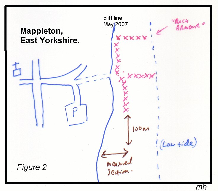
In May 2007 I went to Mappleton with a class of adult students from a University of Hull Lifelong Learning course. Whilst there we discussed the issue of coastal erosion. There had been reports on the BBC local news programme, Look North, about the road being closed at Ulrome and people losing their land and homes over the cliff. Some people were saying the the coastal erosion had been made worse by the coastal defenses. We decided to investigate whether the erosion had been affected at Mappleton. Thomas Sheppard had written that many villages had been lost since roman times in his 1912 book "Lost Villages of the Yorkshire Coast". The loss of coastline can be measured at Kilnsea, where an inscription on the side of the former public house tells how far it was to the cliff edge when it was built. Many people reckon that the rate of the erosion is about 2 m per year. The sea defenses were erected at Mappleton in 1991; there is a plaque at the top of the cliff path saying that the work was funded by the EU. When the fences were built they ran parallel to the cliff with a trackway between the two for vehicular access. The cliffs to the south had been eroded back. By pacing out the distance from the line of the defenses to the cliff about 100 metres to the south we estimated that 64m of cliff had been eroded.
How can we turn this into a scientific report?
1 - what are the key facts?
2 - any additional information?
3 - plan of the report - use the 6Ws to help
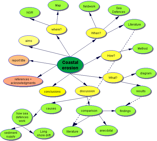
4 - or use a mind map:-
5 - create diagrams, tables, etc.
6 - write the report:-
|
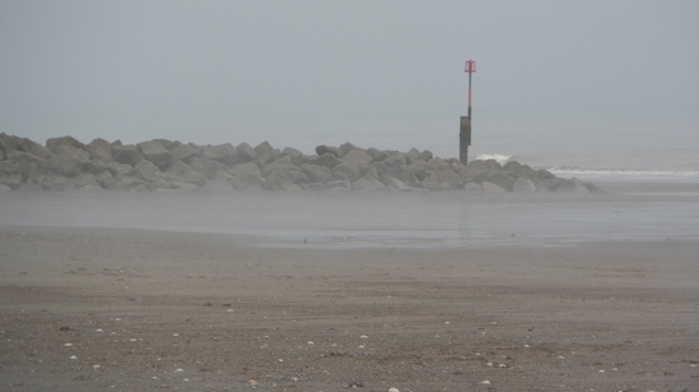
Coastal erosion at Mappleton, East Yorkshire, UK. by Mike Horne. There have been many concerns expressed locally on the television and in the papers that the use of rock armour for sea defenses on the Holderness Coast increases the rate of coastal erosion further south. The cliffs of Holderness are composed of boulder clay: an unconsolidated mixture of clay and larger rock clasts deposited during the last ices ages. (see Horne 2000 for further information). This soft sediment is easily washed away by the sea. At Mappleton coastal rock armour was put in place in 1991 to protect the village from coastal erosion. At the same time a car park, picnic site and road access to the beach were also created. The picnic site has now largely gone due to the erosion of the cliff.
The rock armour implacements trap sand on the beach slowing the rate of long shore drift and allowing sand to buildup on the beach. The higher beach level stops the sea from eroding the base of the cliff, halting the cycle of rotational slumping and allowing the soft cliff line to reach a stable angle. When the rock armour was deposited on the site a line of boulders was
placed parallel to the cliff face, with enough space for vehicular access
between the base of the cliff and the defenses During a visit in May 2007 it was noticed that the cliffs to the south had been eroded back from the 1991 cliff line in a curve. At at point about 100 m south of the defenses the distance between the present cliff and a line parallel with the base of the cliff behind the defenses was paced out and found to be approximately 64m. Sheppard (1912) records that many villages have been lost from the Holderness coast since Roman times. De Boer (1964, quoted in Ostler 2006) estimates that the rate of erosion to be 2 miles in a thousand years; which can be recalculated to 3.19m per year. Ostler records that 374 yards of coastline have been lost at Kilnsea between 1847 and 2004.
From the above table it can be seen that the annual rate of erosion south of the Sea Defenses at Mappleton is almost twice the average at Kilnsea. This could be because the beach south of the defenses is starved of sediment allowing the waves t break at the cliff base at high tides washing away the clay at the toe of the rotational slumping. References:- de Boer G, 1964. Spurn Head: its history and evolution Trans. Inst. Br. Geog. 34, 71-89. Horne M 2000. The Geology of Holderness web-site < http://www.hull.ac.uk/php/chsmjh/holdhome.htm > (updated 2006) Ostler G, 2006. Coastal Erosion and the Lost Towns of Holderness. Humberside Geologist Online <http://www.hullgeolsoc.org.uk/gordon.htm> (viewed June 2007) Sheppard T, 1912. The lost towns of the Yorkshire coast. Reprinted 1986, Mr Pye Books, Howden.
June 2007. |
OK - the above is a quick attempt to turn the fieldwork into a scientific report, based on very little extra background research. It took me about 3 hours to plan and write it.
7 - what did I do wrong?
8 - how could we improve the report?
More accurate fieldwork
Other sources of data
More about the processes
copyright Mike Horne - 2019
Hull Geological Society Home Page Geology Courses Homepage
Copyright statement -
Permission is given for single copies to be made or printed for personal, educational
or non-commercial use.
You may make multiple copies for educational or non-commercial uses if you inform
me. You may not alter any of the pages without permission.
The course notes may contain links to external sites - the content of which is beyond my control. Please respect the copyright of the owners of such sites - a link from my course notes does not imply permission for you to print or redistribute the content of other people's web sites.