
TNotes on Geological Mapping.
tutor: Mike Horne FGS
for the Centre for Life Long Learning
Introduction -
Geological Mapping is the process of gathering geological data in the field and adding that to a topographic map to create a geological map of our own. It involves the careful observation of exposures, searching for other clues about the hidden geology, interpretation of these data to create the map and often then writing a report to accompany the map.
It is fun and it will change the way that you look at published geological maps and perhaps the science as a whole.
First read my introduction to geological fieldwork and if you are attending my class at the University you must read and understand my risk assessment for fieldwork.
In most of the U.K. there is not much geology exposed except on the coast. The number of quarries seems to be falling rapidly, though there are efforts to conserve the ones remaining as SSSIs and RIGS. So much of our fieldwork for map making involves looking for clues about the geology that lies beneath our landscape.
[These notes are intended for students mapping in East Yorkshire - where the geology consists of Mesozoic sedimentary rocks with overlying quaternary deposits, including Tills. So I have not included details about metamorphism, igneous rocks or complicated structural geology because they are not needed in our area.]
How to map:
1) preparation -
Make sure that you know how to measure true dip using a clinometer and that you know how to use map coordinates.
Obtain your large scale base map - 1 to 10 000 ( or the old 6" to a mile) scale is excellent. You will need a good clean copy as a master document to work from and another copy cut into manageable sheets for use in the field.
Do a literature search - read about the local geology, field guides, articles in journals, map memoirs, etc. to get an idea of the geology of the area you intend to map. Visit the local library, contact the local geological or natural history society, search the world wide web. Do not believe everything you read!
Try to find borehole information - look in map memoirs and journals. Perhaps contact the British Geological Survey, local authority or water supplier. Decide if you can trust the data and interpretation.
Have a look at published geological maps of the area BUT do not be tempted to copy them. Copying them defeats the point of you own mapping and you will not get so much out of it. You will also be copying any mistakes they made - your task is to record and interpret the present day evidence which may not have been available in the past.
Get to know the geology and landscape of the are generally before you start the mapping in any detail. This will give you a "feel" of the geology, help you plan the work and enable you to do risk assessments.
Visit some key exposures to view the rock types in their unweathered form. This may mean going outside your mapping area to find these exposures. Whilst you are there pay attention to the weathering and soils that form on the top of the rock.
You can now start to establish your own lithostratigraphy and biostratigraphy.
Calibrate you compass - your compass points to magnetic North and you maps coordinates are based on true North. If you want to record directions accurately then you should calculate the difference between your compass and the North on you map and adjust all readings you take in the field accordingly. To do this - when you are in the field find where you are exactly on your map, look for a landmark in the distance, take a bearing with your compass and then compare that with the angle from North on your map using a protractor.
2) equipment required -
There is not much point in doing fieldwork if you do not have the right equipment. But you will not want to carry too much around with you. So plan each day's work carefully in advance.
Make sure that you have the right clothing for the weather conditions and sensible footwear. Remember to have some food and drink in your rucksack, and perhaps a first aid kit and mobile 'phone.
For general mapping you will need - your base map, your geological note book, pen or pencil, a large clear plastic bag (so you can write in your notebook in the rain, a compass, a clinometer, a grain size scale, a geological hammer, a camera, some sample bags.
If you know you are going to go into quarries or are visiting coastal exposures take your hard hat, tape measure, chisel, trowel, perhaps some old newspapers to wrap larger fossils and rock samples.
If you are in areas with little exposure then take an auger.
3) fieldwork -
Always remember that you will be working mostly on private land. Where possible get permission and be respectful to landowners - explain what you are doing and you will often get snippets of useful information in return. Do not trample crops and do not disturb livestock. Never neglect your own safety or the safety of others.
Exposures - get the maximum information from exposures - rock types, thicknesses, dip, dip direction, fossils, etc. Collect small samples for comparison with other exposures, and perhaps future lab-work such as making thin sections, sieving for microfossils or chemical analysis. Getting dips and directions can be very helpful for you mapping - they can help you understand geological structures (such as folding, faulting and unconformities) and help you predict where outcrops should be (remember that horizontal beds run parallel to contours).
Field walking - look for fragments of rock and fossils, but remember that these may have moved down slope from the sub-crop. Look for changes in soil. Keep to established footpaths or the edges of fields whenever possible - you will not damage crops that way and often the is some bare soil there most of the year. Farmers may move large boulders to the edge of the field so they do not cause damage to farm implements.
Stream sections - look in the bed and banks of streams and rivers for exposures or bits of rock. Remember rock fragments may have moved downstream from the outcrop.
Temporary exposures - look for road works, newly dug graves, gate post repairs, ditch clearance, rabbit or fox hole - any hole in the ground that may reach bedrock or the subsoil or provide a spoil heap.
Augering - using an auger to take samples of the subsoil and rock fragments. Do not screw the auger deep into the ground and then try to lift it out - you may break the auger or do yourself a mischief! Screw the auger in a short distance then lift it out, look at the sample and then put it back into the same hole, repeating the process until you hit something solid, get a satisfactory sample or just can't get any deeper.
Landscape - pay attention to the landscape: you will get clues about the geology. Changes in slope are probably due to a change in geology: a concave slope might indicate a soft rock under a harder one. Look for dip and scarp slopes. Look for spring lines indication a permeable rock overlying an impermeable one. Dry valleys and underground drainage are indicators of limestones or chalk (chalk is a sort of limestone). Look at the depth of the soil - soils on limestones are usually quite shallow. Differences in plant life or land use are probably related to the the geology.
Human activity - look at the building stone and walling in the area - local rocks will be used if suitable. Perhaps garden rockeries include local rocks. But be a bit skeptical about the evidence if humans have been involved - rocks used for walls, tracks, etc. may have been imported into the area or moved around it. There may be clues in place names - such as "The Old Brickyard", "Sandy Lane", "Quarry Hill", etc. It may be worth looking at old maps and historical books for evidence of old quarries and other land use. And always remember to visit the local pub and chat to people - you can often get bits of help by asking the locals "do you know about any quarries around here?" and things like that.
4) creating the map -
In the field - mark localities on to the base map field slips that you have with you. I suggest that you mark the spot with a cross and put the locality number used in your note book beside it. Then write the details in you note book, including the grid reference and locality name from the map. It is probably best to use a sharp hard pencil or a blue indelible pen.
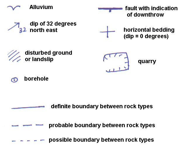
When you have an exposure then show the dip with an arrow pointing in the direction of the dip and the dip in degrees written beside it. The head of the arrow should be on the place that you measures the dip and the locality number should be beside it.
You could show an augered transect with little circles and an abbreviation for the rock type found beside it, rather than giving each point a locality number.
You can use symbols or words to record landscape features that you think are significant.
On the good copy - Copy most of the information from you field slips onto a good copy of the map after each days fieldwork. As the base map is probably printed in black on white, use a very fine blue pen. You can then start to mark in the boundaries between the rock types. Use a continuous line where you are sure of the boundary location, and dashed lines when you are less certain or guestimating. The same goes for other features like faults; faults are usually shown as a thicker line than boundaries.
The final geological map - This is a map that presents the results of you field mapping and it is best to to a tracing based on you good copy of the map, showing the geology, exposure details, some landmarks, major roads and topography. It should not be cluttered with too much detail but anyone using should be able to find their way around it. You do not need to include all locations and location numbers, you should identify them by their grid reference in your report.
Colour the final map - either follow the conventions of the British Geological Survey, or invent your own colouring system. Use faint colours for most rocks so that the colouring does not hide any of the details of the map. You can use brighter colours for thinner strata or outcrops to make them more obvious.
Remember to include a key for the symbols and colours used! Don't forget a scale too!!
5) writing a report -
The report gives further explanation and interpretation of the map as well as adding details about the lithostratigraphy and biostratigraphy.
There is a standard format for a map report (similar to a BGS map memoir) which presents the information in a logical order. There is no reason why you cannot do your report differently, but following accepted practice is often easier!
[As with anything you write remember to keep to the copyright laws and avoid plagiarism. The use of quotations and diagrams from previously published work must be acknowledged]
The report would normally consist of :-
Title page and author - should be concise and informative - probably "The geology of...."
Abstract - a short précis of the report that should make sense without reading the whole report, designed to give the reader the key points about the geology of the area.
The main part of the report split into sections or chapters (such as) -
Introduction - including the aims of the mapping, details previous research in
the area (from your literature search), techniques used, and things like that.
The rocks - a descriptive listing of the rock types in the area arranged in
stratigraphic order with the oldest first. Include diagrams, pictures and logs
wherever possible.
The biostratigraphy.
The superficial deposits -
Quaternary.
Geological history of the area.
Geology and landscape
Economic geology - uses of the rocks and water supply.
Conclusions.
References or bibliography - remember to follow accepted standards for referencing.
Acknowledgments - thank the people who have helped you.
And don't forget to include a copy of the final map with your report, either attached to the back cover or in the same folder.
Geological fieldwork techniques - course notes
copyright Mike Horne - 2019
Hull Geological Society Home Page Geology Courses Homepage